In a recent article, “Heidelberg through the eyes of a deltiologist” (click here to view), I committed to follow that article up in similar vein on the town of Standerton.
The Heidelberg article unexpectedly obtained international attention in that it was also taken up in an international philatelic magazine, Forerunners (2023). This interest indicated to me that constructing short articles of this nature, relying on picture postcards to visually support the text, is of interest to a broader reader group.
This article, therefore, like the Heidelberg article, reflects on Standerton’s visual history up to the 1920s, relying on picture postcards of that era.
Standerton, part of the Mpumalanga province, was an obvious next article in that it is just over 100km from Heidelberg. The two towns were also linked via the rail line. Both Standerton and Heidelberg also obtained municipal status in the same year, namely 1903.
Unlike the town of Heidelberg (and other early South African towns), I found that the history of early Standerton has not been well recorded, resulting in many historical gaps and unanswered questions. Whilst historical snippets could be found, no cohesive record of the town’s history is available electronically.
The history of the little village town, Val, located between Heidelberg and Standerton has probably been better recorded than that of Standerton. Scholtz (1966), whilst containing some flaws and outdated, was, however, a useful source, without which I would have been grappling around in the dark even more.
Unlike Heidelberg, Standerton did not have the honour of being a capital town of the Zuid Afrikaansche Republiek (1880 – 1883).
The histories of smaller towns are often revitalised when the older generation elects to settle in these towns as part of their retirement plans. In doing so, some residents then get involved in researching their new town’s history and even become tour guides. Such an honour has seemingly not been bestowed on Standerton yet, and probably never will in that the town has lost its overall appeal.
The few historical aspects of significance that stood out for me during my research on the history of Standerton are briefly discussed in this article. These include the two Anglo-Boer Wars, the 1911 flood, the railway station, and the Kruger Bridge. Other than farming activity in the immediate surroundings, it was really the railway station and military activity that placed the town on the map – for a while at least.
The town Standerton lies on the banks of the Vaal River in the Mpumalanga province (called Eastern Transvaal Province in 1994–95) and is surrounded by mixed agricultural activity. The town formed part of the former Transvaal province until 1994.
Today, Standerton forms part of the Lekwa Local Municipality.
A tourist attraction today, the Grootdraai Dam is situated in the upper reaches of the Vaal River less than 10 km upstream of Standerton and was only completed in 1982.
Standerton, initially referred to as Standersdrift, was named after Adriaan Hendricus Stander.
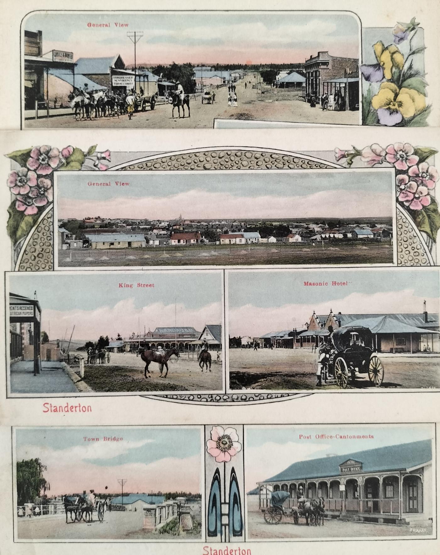
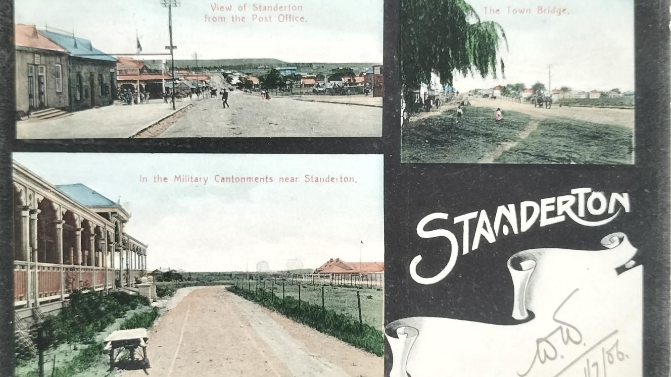
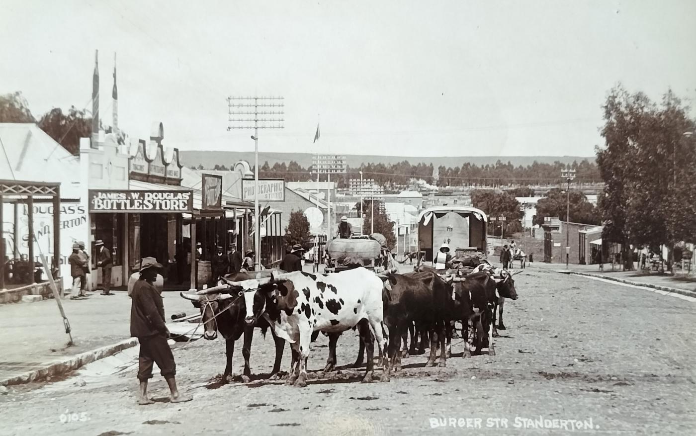
These Standerton town scenes are compiled from three different postcards. The top view is a general street view (probably Burger Street) showing the shop Groves and Hansen on the left and a Hairdresser, News agency and Tobacconist business on its right. The second row of images from the bottom shows King Street with Landau & Co in the background (left) with the Masonic Hotel (right). The bottom row shows the bridge in town as well as the Post Office in the Cantonments. All three cards (numbered 2535, 2536 & 2537) were published by Sallo Epstein & Co (Circa 1908). On one of the cards, it is stated by the sender that the card is rather flattering in that the place (Standerton) does not look as nice as on the card.
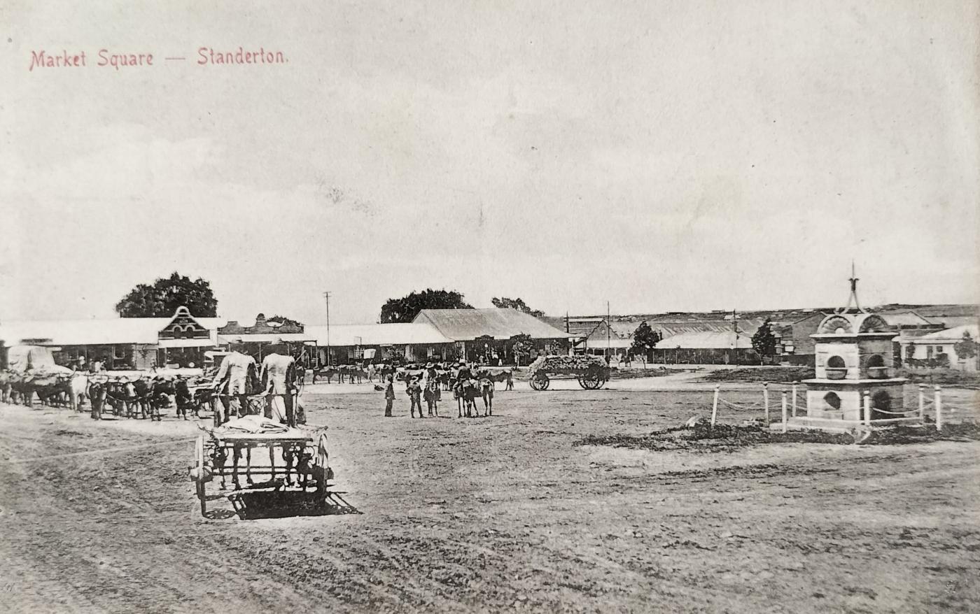
Standerton market. Postcard number 1828 was published by Sallo Epstein & Co (circa 1905). On the right stands the memorial erected for those who died in the Standerton concentration camp during the Anglo-Boer war. In the background, on the right, the Masonic Hotel can be seen.
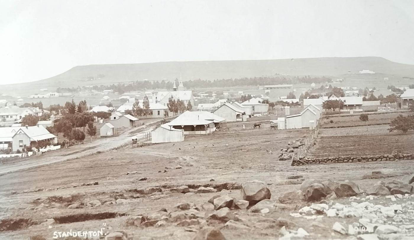
A general view of Standerton showing the Dutch Reformed Church and Stander Kop. The message on the back of the card states: “All soldiers will recognise dear old Standerton! It has not moved an inch and is full of tin houses".
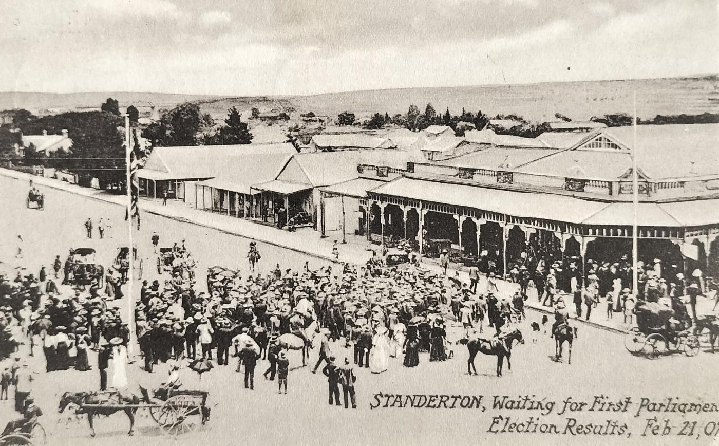
Awaiting the first Parliament election results on 21 February 1907. General Smuts was also a member of Parliament for Standerton. No publisher details.
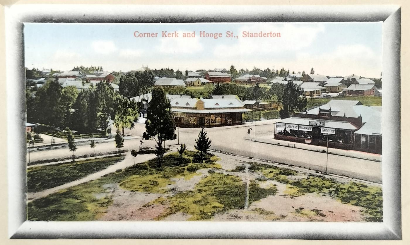
Street view of Standerton (Corner of Kerk and Hooge Street). The general store on the right belonged to Orr and Pedley. The publisher of the card was ML Greenblatt who was also based in Standerton (circa 1907).
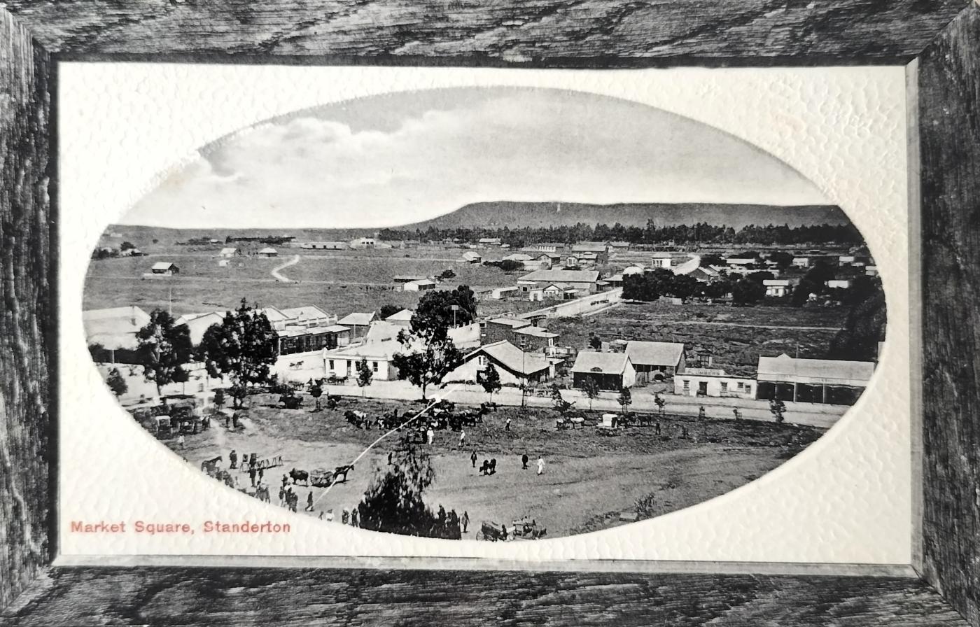
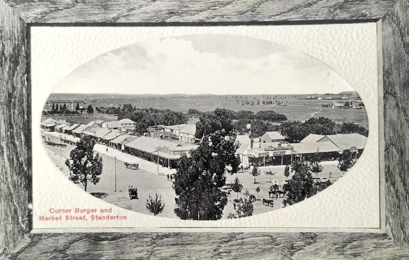
General view over Standerton with the Market Square in front and Stander Kop visible in the background. Visible in the centre of the image is the Natal Bank, Imperial Mineral Work as well as a plumbing establishment. The publisher of the card was ML Greenblatt who was based in Standerton (circa 1908).
1. Adriaan Hendricus Stander (1817 – 1897)
Stander was born in George on 12 January 1817 and passed away in Standerton on 5 September 1897. He married Elizabeth Catharina Welmans on 3 October 1836 in George. Elizabeth was born on 8 Nov 1819 and predeceased her husband on 18 October 1888. The couple had 5 children.
Stander was a restless soul in that he moved around often before finally settling in Standerton.
He is described as a farmer, hunter, trekker, people’s man, soldier, statesman, and campaigner for freedom – that was until 1877, aged 60, with the annexation of Transvaal during 1877 when Stander elected to support Shepstone and served on his Legislative Council.
As an 18-year-old he fought under the command of Commandant Rautenbach against the Xhosas near Tromperttersdrift. In the early 1840s, he assisted the Griekwa captain, Adam Kok in two wars against Andries Waterboer.
Stander also led a group of protesting Boers when the Orange Free State was declared a sovereignty in 1848. For this activity, he was arrested but was released after three months and in return received a hefty £500 compensation due to wrongful arrest.
Stander fought several additional battles until he finally settled in the Transvaal in 1863, on the banks of the Vaal River, which later became known as Standerton.
Not long after settling on the shores of the Vaal, Stander was attacked by a Basotho gang. His son Adriaan was killed in this conflict (12 August 1865) and Stander himself was wounded in the leg, resulting in him walking with a limp for the remainder of his life. Following this event, Stander and three of his sons were again called up following the announcement that conflict was developing against Moshesh.
On the farm, which Stander allegedly bought for £25, he hunted lion, rhino, kudu, eland, and other large game. The skin and horns from these animals, which he sold in Durban, generated a good income for Stander.
The decision by Stander to side with Shepstone in 1877 drew criticism from his countrymen. This all while his fellow countrymen (the Boers) were in the throes of preparing to take on the British powers to regain freedom. Was Stander viewed as a traitor following this revised political stance?
The same man was in the service of his country by fighting 5 tribal and other wars, one of which was against the British at Boomplaas and another with Paul Kruger against the Matabele chief Moshesh in Marico. He co-signed the Orange River Convention (February 1854) - A real statesman. The same man, in whose veins warriors’ blood was flowing, who extended a threat against the British in Bloemfontein some 23 years prior but all of a sudden elected to side with his previous enemy.
2. Establishment of the town Standerton
The South African Republic's Volksraad approved the formation of a town at the Vaal River drift in 1876 following which Standerton was proclaimed in 1878 on Stander’s farm called Grootverlangen (translated into Immense Longing).
In the Government Gazette of 9 February 1876, reference is made to the establishment of Standersdrift. On 14 December 1878, the town of Standerton was proclaimed by Shepstone. The position of Standerton was significant during the height of the wool trade in that it was halfway between Heidelberg and Marthinus Wesselstroom (Wakkerstroom today).
A correspondent from The Times was very disparaging about the young developing town stating on 29 December 1881 that a “drearier spot than Standerton is scarcely to be found on the face of the earth and that the town itself consists of sheds of corrugated iron, a large percentage being drinking shops”.
Following the discovery of gold on the Witwatersrand, Standerton became a hive of activity with transport wagons loaded with mining equipment destined for Johannesburg traversing through town.
Also named after Stander was Stander’s Drift, the river crossing over the Vaal River (bridged in the early 1890s), and the hill close to the town which is still called Standers Kop.
Standerton obtained municipal status in 1903.
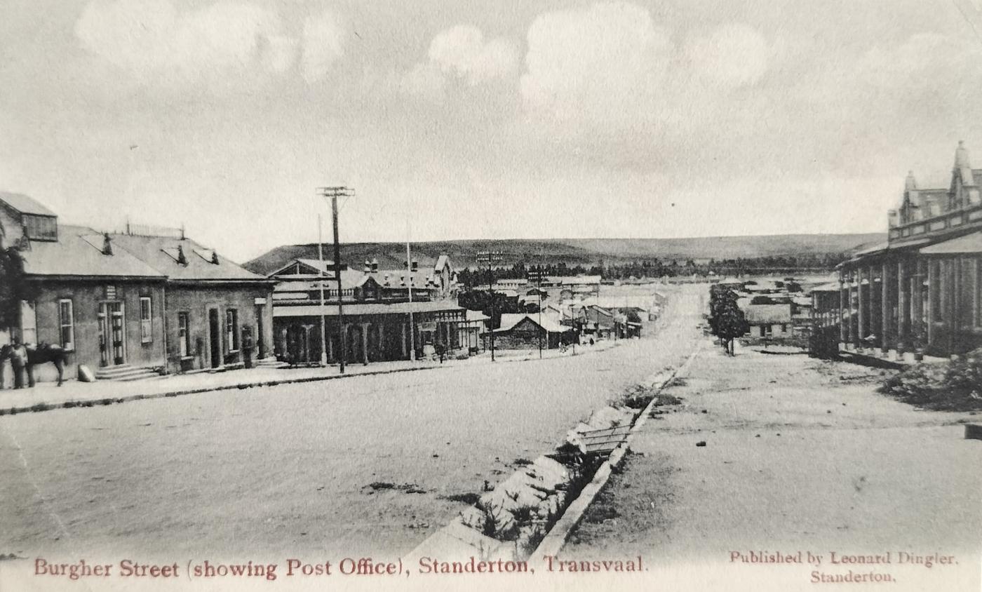
Standerton street scene (Burger Street). The publisher of the card was Leonard Dingler from Standerton.
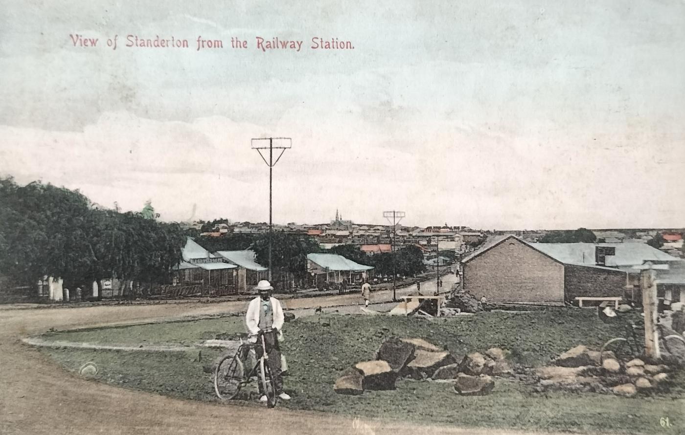
Standerton as seen from the railway station – down Burger Street. The vacant land behind the man with his bicycle was later occupied by Standerton Creamery. The bicycle standing against the pole on the right in all probability belonged to the photographer. Postcard number 1827 was published by Sallo Epstein & Co (circa 1905).
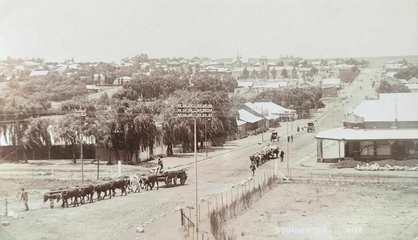
Standerton as seen from the railway station. A similar view to the above, now with the Standerton Creamery in place. This real photo postcard was published by SAPSCO.
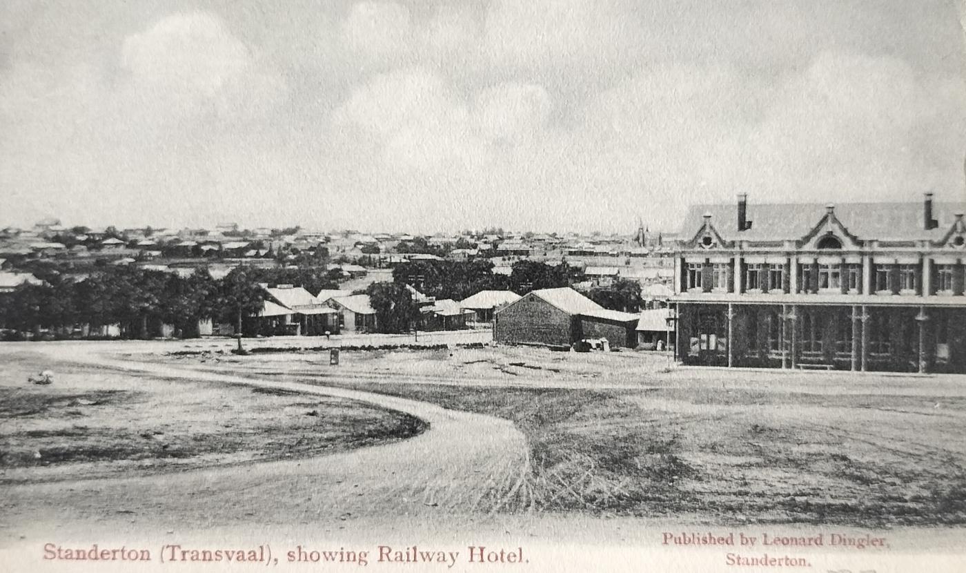
View from Standerton Railway station showing The Railway Hotel. This card was published by Leonard Dingler from Standerton (circa 1905).
3. Military history
The military history of Standerton stands out.
3.1 First Anglo-Boer War
During the 1st Anglo-Boer War, the British garrison in the town was besieged by the Boers for three months (29 December 1880 to 26 March 1881).
The first shots were fired at Standerton on 29 December 1880. The siege came to an end on 25 March after 88 days. Five British soldiers were killed and 9 wounded during this period.
Picture postcards were not produced as early as the 1880s meaning that no postcard imagery will be found on any 1st Anglo-Boer War activity.
3.2 Second Anglo-Boer War
From an actual conflict point of view, other than a few skirmishes, the war did not have a severe impact on Standerton.
On the morning of 23 June 1900, the British, under the command of General Redvers Buller entered Standerton and occupied the town without any resistance from the Boers. Buller used the home of John Gibson which was situated where the Town Hall stands today (built 1929). It became known as Buller’s Lodge at the time. A tent hospital was established next to the railway line, where the Nestlé Factory stands today.
On arrival, the British pitched camp and positioned their artillery on top of Standers Kop with gun emplacements on top of Joubert Kop (west of Standers Kop).
South of the town, the Vaal River formed a natural barrier and fortifications were constructed on nearby kopjes.
During the conflict period, farming activity and trade came to a near standstill resulting in the town experiencing a serious economic decline.
The British garrison that later based themselves in Standerton, however, contributed to a short period of welfare.
The Vaal River school was used by the British as living quarters. A blockhouse factory was also erected near the school.
To delay the onslaught of the British, the Boers blew up the rail bridge lower down the river. This was an important means of transport for the British in that supplies, troops, and ammunition were transported by rail. After the rail bridge was blown up, Buller’s men built a bridge next to the wagon bridge within 8 days.
In Standerton’s new Municipal cemetery, to the west of town, is the British Garden of Remembrance where many British soldiers who died during both Anglo-Boer wars lie buried. The total deaths came to 556 British soldiers. Soldiers originally buried at Standerton’s old military and civilian cemeteries, as well as in smaller surrounding towns, were reburied at Standerton.
3.3 Standerton Commando
Members of the Standerton Commando partook in the military crackdown during the 1922 Witwatersrand Miners’ Strike.
3.4 Standerton Concentration Camp
The concentration camp in Standerton was situated east of the old wagon bridge (Paul Kruger bridge) next to the Vaal River. One record suggests that 857 women and children died in the camp with another suggesting a total of 716 deaths.
In one sad instance (of many), Margrietha Swart from Roodekrans lost 8 of her children within a 19-day period in the concentration camp.
Shortly after the war, the Jewish mayor of Standerton at the time, Charles Landau, donated a memorial fountain in memory of women and children who lost their lives whilst in the concentration camp. This memorial fountain was erected on Market Square.
The concentration camp cemetery is located in the old municipal cemetery, not far from the original concentration camp. This cemetery also has a memorial for women and children who died whilst held captive in the concentration camp.
Near the concentration camp cemetery are the graves of individual Burghers.
Not well recorded is the fact that there was also a concentration camp for Black South Africans in Standerton.
3.5 Cantonments in Standerton
There were four large cantonments in the Transvaal Colony, namely Pretoria, Potchefstroom, Middelburg, and Standerton.
After the hostilities ceased, Joseph Lockwood Hall, who also later built the Standerton town hall, was in charge of building operations at the Standerton cantonments.
The Post Office located in the cantonment was run by civilian Post Office officials and not by the military.
The cantonments closed in 1906 resulting in the Standerton businesses taking strain, amongst them 6 hotels.
Two fires, during 1905 and 1908 respectively, destroyed some of the buildings in the cantonments. In the latter fire, two lives were lost.
The second fire in 1908 conflicts with the date the cantonments closed (1906). Could the fire of 1905 have been the only fire with the date of the second fire being erroneously recorded on the picture postcard below?
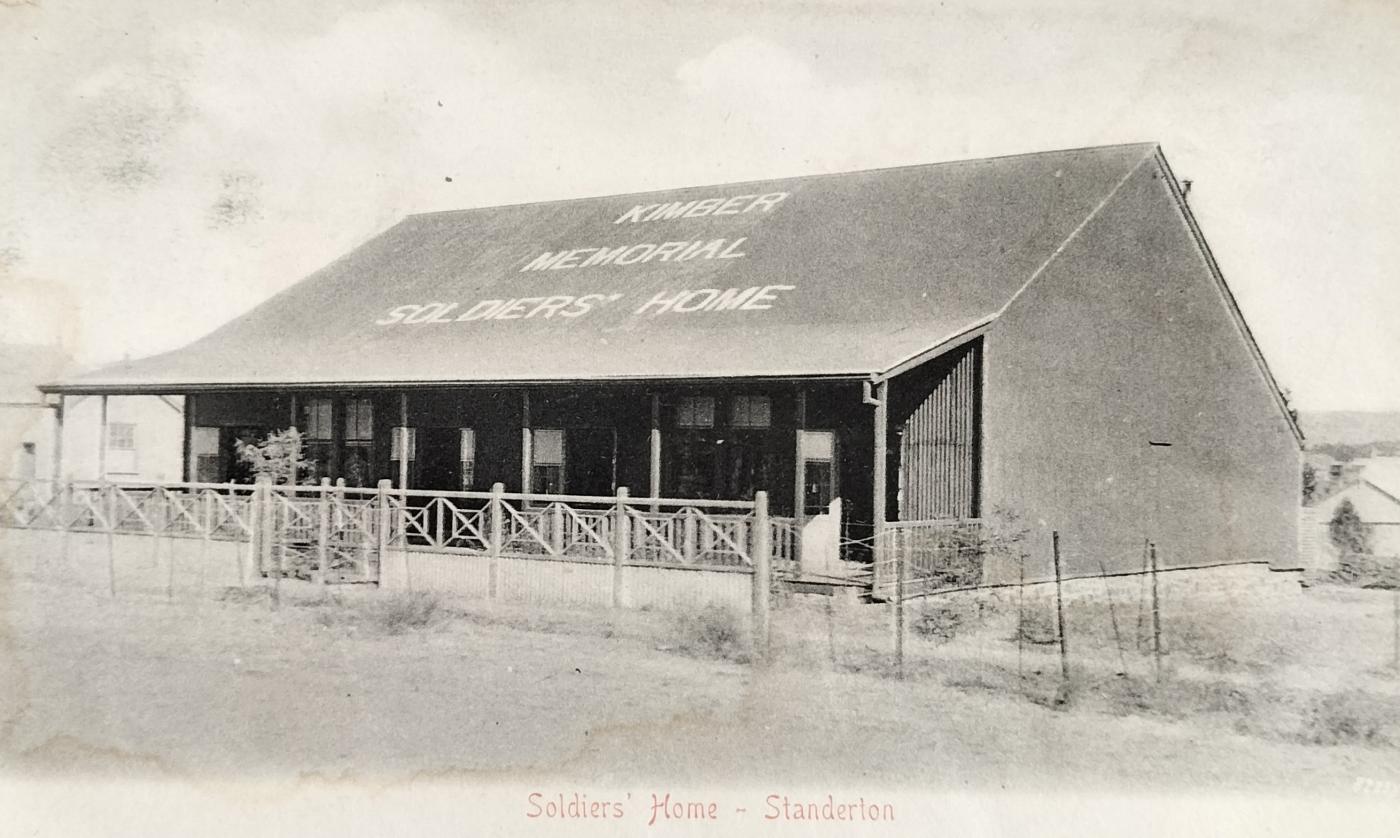
The Kimber Soldiers Memorial Home in Standerton. This building was probably located in the Standerton military cantonment. An unnumbered card published by Sallo Epstein & Co circa 1903.
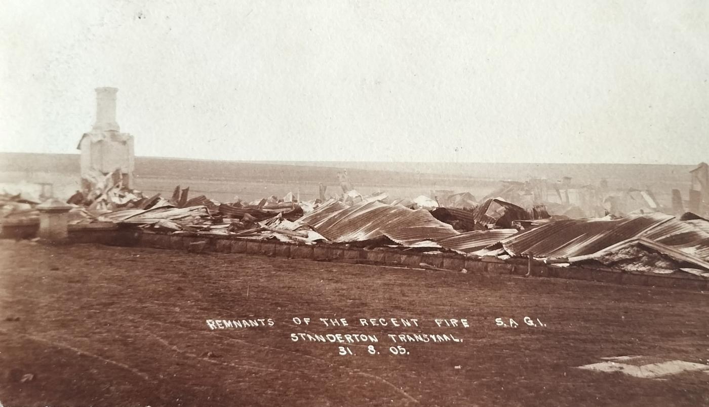
Remnants of a fire on 31 August 1905 at the SAGI (South African Garrison Institute). This complex was in the military cantonments in all probability. The publisher or photographer of this real picture postcard is unknown.
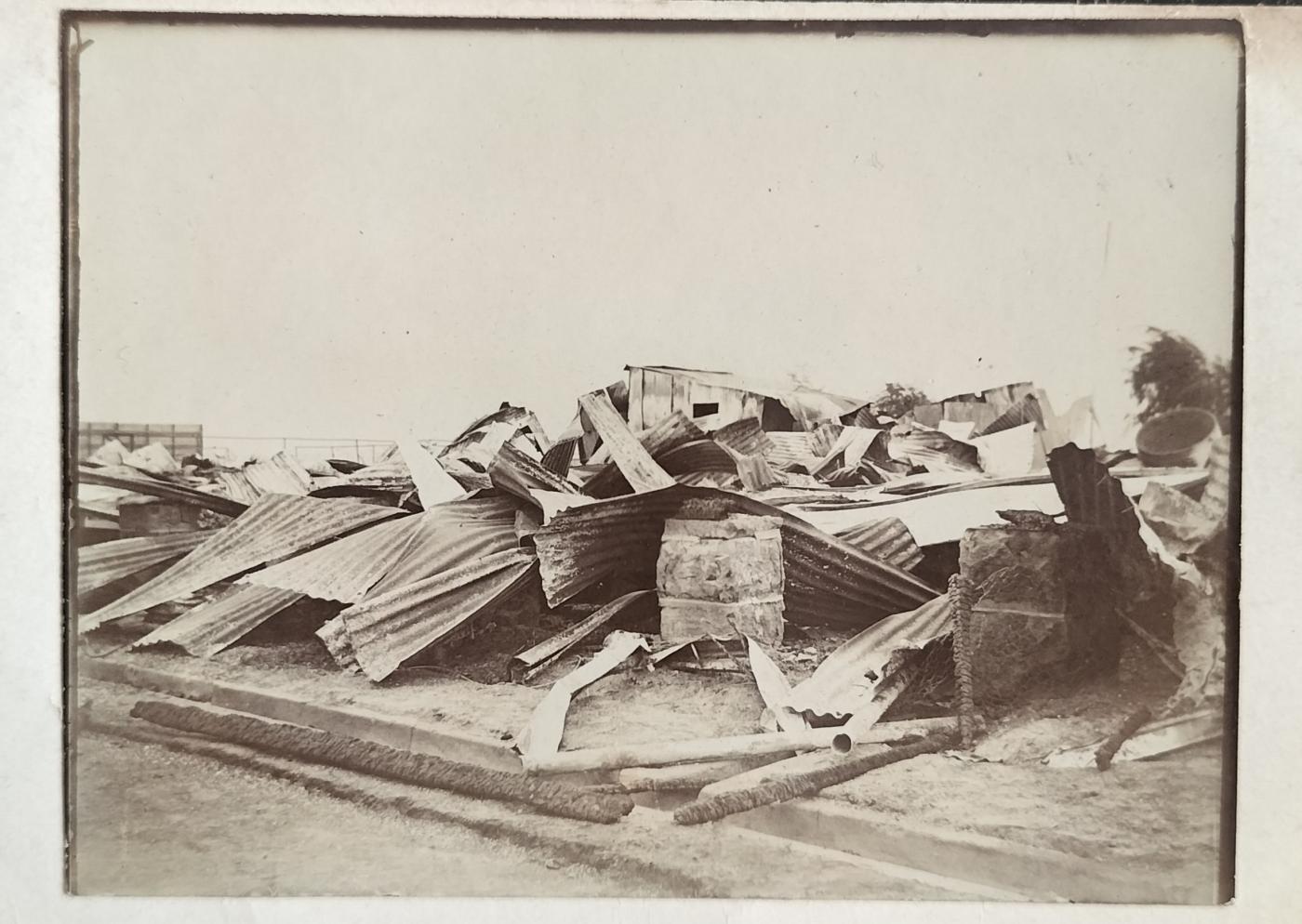
A second fire at the Standerton Officer’s Club in 1908 in which it has been reported that two lives were lost. This card is a home-made card in that the image has been pasted on a stock-standard postcard resulting in the publisher and photographer being unknown.
4. Early Standerton businesses
The Jews, as in so many other South African towns and cities, have played a cardinal role in Standerton’s economic development.
4.1. Jewish businessmen in town
The first Hebrew Congregation was established in town in 1898.
- Charles Landau – Charles was born and educated in London in 1860. He arrived in South Africa (Orange Free State) in 1874 where he married Irish-born Fanny Ethel Barron. Charles lived in Standerton from 1898 and was elected as town mayor on four instances, namely 1904, 1905, 1922-23, and 1924-1925. He started the firm C Landau & Co. External shop signage indicated that the shop sold anything from needles to steam ploughs to female fashions. Charles died in 1943, aged 82, and is buried in Standerton;
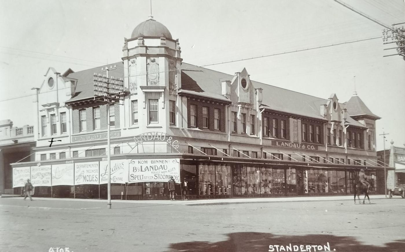
A SAPSCO published card showing Landau & Co shop in Standerton (circa 1910). The sign at the front door states that anything from a needle to a steam plough can be obtained from this shop. The cross on the left of the card indicates where the millenary was located. The sweet smell of sugar and tobacco, mixed with the smell of leather saddles and gear, linen and medicine trommels was described as the typical smells experienced in shops of the earlier years.
- Isaac Michel – Town mayor in 1918/19 and 1926/27;
- Charles Jackson – Owned the National Hotel. After it burned down, he bought the Standerton Hotel and a butchery, both of which operated during the hostilities. The stand on which the disused synagogue stands today was donated by Jackson;
- Julius Hesselson – See section below under ’Photographers’;
- David Reiff - See section below under ’Photographers’;
- Greenblatts – There was at least one mill in town in the earlier years. Although the Standerton Mill was only established in 1947, there also seems to have been a mill in town earlier called Greenblatts. They mainly manufactured and supplied yarn and woven industrial fabrics. It is thought that this may be the same entity that was just renamed;
- Victor Simon – Owned a hotel and other businesses; and
- Cohen & Co – Business entrepreneur.
It is my understanding that Jewish entrepreneurial activity in Standerton has come to an end entirely.
4.2 Other businesses included:
Early business was mainly in the hands of three entities, namely Gibson, Paddon & Brock, and Landau & Co.
Gustaf Preller (popular journalist and historian) stated that he also worked for Paddon & Brock as a young man.
Pre 1891, good money was also made with the transporting of postal carriages and other forms of transport, via ferry, across the Vaal River until the establishment of the Kruger Bridge.
Hotels in town were popular, especially when the British garrison was in town.
The first Bank to settle in Standerton was De Nationale Bank der Zuid-Afrikaansche Republiek Beperkt (1 March 1894). Standard Bank opened 7 years later (1901) followed by the Natal Bank, which opened in town on 1 March 1903.
Standerton Hospital was only built in 1922.
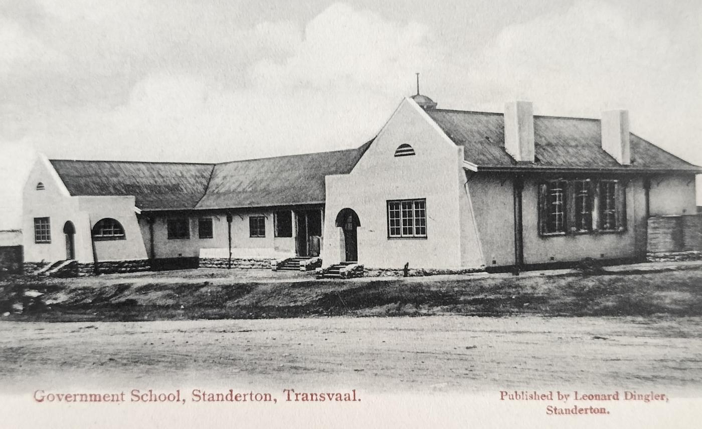
A Government School building in Standerton. To date, it has not been determined which school this was. Card published by Leonard Dingler from Standerton – circa 1905.
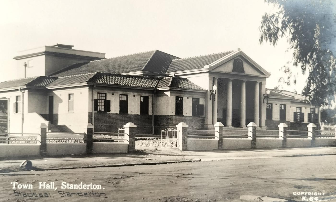
Standerton Town Hall was built between 1927 and 1929. The architect was Joseph Lockwood Hall. The complex features red brick similar to his earlier work on buildings such as the Pretoria Normal College. He also designed the Pretoria and Benoni Town Halls.
5. Religious establishments
Unlike several other South African historical towns, the town of Standerton was not developed with a church in the centre of town, nor did any earlier church buildings stand the test of time in that they were all demolished and rebuilt.
5.1. Die Gereformeerde (Dopper) Kerk Standerton
Although the Reformed Church in Krogh Street saw activity as early as October 1904, the cornerstone for the new building was laid by the Reverend Martinus Postma (6 May 1905). The church has been built on one of the higher points in town.
Sixty five years later, this church complex required so much attention that it was decided to demolish the complex and erect a new building in the same spot. The cornerstone of the new church was laid on 21 February 1970.
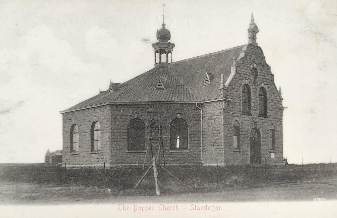
Early Dopper Church (Gereformeerde Kerk) complex in Krogh Street, Standerton. Although the building has a bell tower, the bell has not been installed as suggested by the bell mounted on the wooden structure next to the church. The church complex, built in 1905, was demolished in 1970 and replaced by a new complex. This unnumbered card was published by Sallo Epstein & Co (circa 1905).
5.2 Nederduitsch Hervormde Gemeente
The cornerstone was laid on 22 January 1898 and replaced in 1947 by a new building.
5.3 Nederduitsch Gereformeerde Kerk
The church was established in 1877, two years before the town was proclaimed.
The initial small church building was later bought by the Transvaal Teaching Department and used for teaching purposes.
The second church complex, on the corner of Caledon and Andries Pretorius Streets, had a building design in the form of a capital ‘T’ and was a near replica of the church building in Utrecht in Natal (KwaZulu Natal today), some 160 km away. The cornerstone of the Standerton church building was laid by General Joubert on 25 October 1889.
Enlarged between 1895 and 1914 to accommodate 1,500 churchgoers, this beautiful building was sadly demolished some 51 years later (1941), confirming the value of the historical photographs as featured on picture postcards included in this article.
In front of the current church stands a Burgher Memorial of the Boers of Standerton and vicinity who gave their lives for the freedom of their people and country.
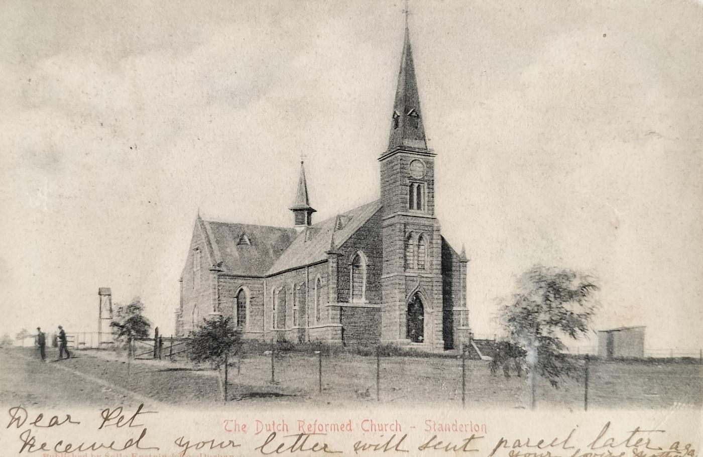
Dutch Reformed Church in Standerton. The second church complex, on the corner of Caledon and Andries Pretorius Street, had a building design in the form of a Capital T and was a near replica of the church building in Utrecht in Natal (Kwazulu Natal today), some 160km away. The cornerstone of the Standerton church was laid by General Joubert on 25 October 1889. This unnumbered card was published by Sallo Epstein & Co (circa 1905).
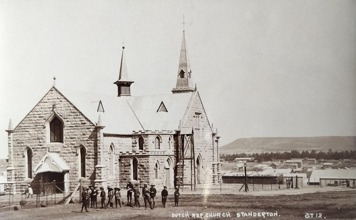
Dutch Reformed Church in Standerton from a different angle with Stander Kop visible in the background. Enlarged between 1895 and 1914 to accommodate 1500 churchgoers, this beautiful building was sadly demolished some 51 years later (1941). This real photo postcard was published by SAPSCO (circa 1908).
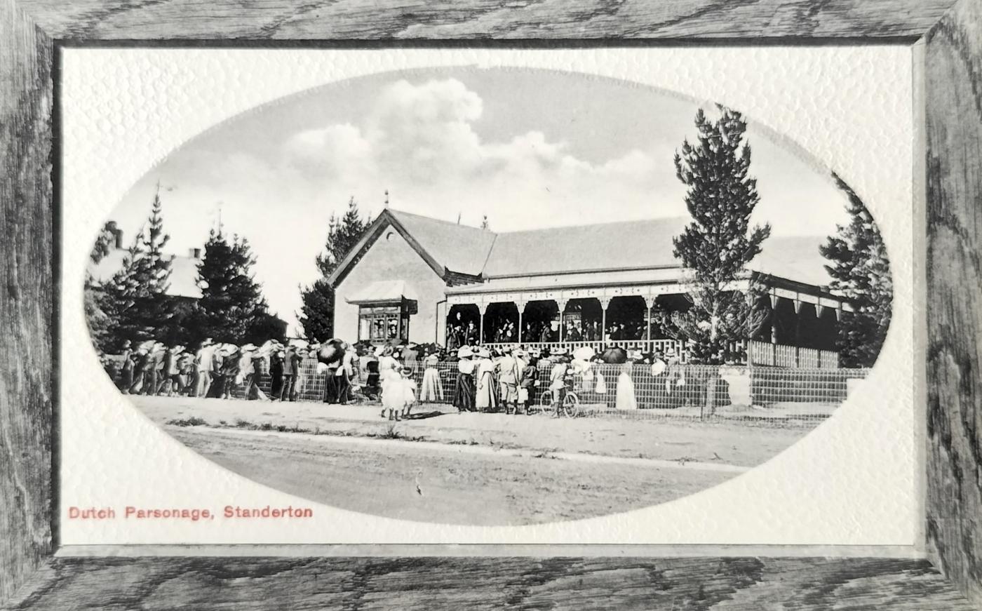
A crowd at the Dutch Parsonage. This house was probably linked to the Dutch Reformed Church in town. The card was published by ML Greenblatt from Standerton (circa 1910).
5.4 Jewish Synagogue
A Jewish congregation was established in 1898 in Standerton with a synagogue only being built in 1929.
5.5 Other religions
- Methodism – Rev. John Crooks was appointed as the first Methodist Minister in Standerton in 1902
- St. Andrew’s Anglican Church – Original church building completed in 1906. The current complex was completed in June 1951.
6. Railway
Standerton was already an established town when the railway infrastructure was developed in the town.
Rail traffic between Natal and Standerton opened on 27 August 1895 and three months later a line opened between Standerton and Heidelberg (15 November 1895).
The original Standerton station site ran parallel to Standerton streets, in line with the market square, and located on higher ground to the west which overlooked the town. From a distance, the group of buildings in the station yard appeared as a separate village.
According to the original plans, the Standerton station building was designed by the Natal Government Railway (NGR). Although the internal layout followed the NZASM (Netherlands-South African Railway Company) type, the rest of the design (especially the exterior) differed markedly from the other large NZASM station buildings. Special features, not devoid of some 'English' flavour, were the ornate pointed gables of the raised centre section of the roof which faced the platform and the street respectively.
The station building, of roughly dressed natural stone in an irregular pattern, was constructed by the firm of Lindsay & Perie. It contained toilets, waiting rooms, an entrance hall with an office, a luggage room, and offices for the assistant station master and train conductors.
Another unusual building with its own gables, which stood separate from the main complex, was the station-master's house with a living room, kitchen, and pantry.
During the extensive railway upgrades of the 1950s, the railway station was sadly demolished, leaving the houses isolated from the town. There are still remnants of the NZASM presence in the town by way of a single street with semi-detached cottages.
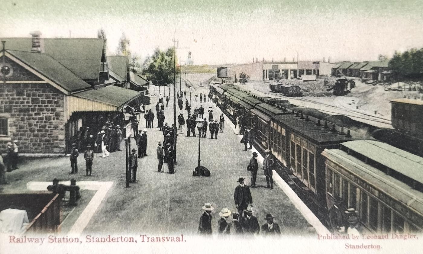
Railway station in Standerton. This building no longer exists. Card published by Standerton-based Leonard Dingler (circa 1908).
7. Kruger Bridge
The bridge over the Vaal River linked the road to Volksrust and other smaller towns south of Standerton.
Standerton also has one of the earliest bow-string bridges built over the Vaal River (the superstructure is of a later date). The original bridge, manufactured in 1890 by Harkort in Germany, was named after President Kruger.
Before the Government invested in the bridge, the German factory was visited where the pre-erected structure was on display. The delegation was clearly satisfied with the quality thereof, whereafter the bridge was demounted and shipped to the ZAR.
Out of respect for President Kruger, the Boers did not blow up this road bridge during the Anglo-Boer War. The railway bridge near town did not, however, receive the same respect from the Boer.
This bridge comprises coursed, rough-hewn sandstone abutments with a central pier that supported two spans of triangulated bow-string trusses spanning 42 m each. The passage was 3,6 m flanked on each side by 1,6 m footways. The steel superstructure was later replaced with conventional triangulated steel girders. The tender for the construction was initially awarded to Fowler & Co. of Britain but was cancelled and the tender was awarded to Royce. This is the largest steel-span road bridge erected by the ZAR. Once this bridge was completed, the workforce attended to erecting the steel superstructure bridges over the Crocodile River, 'Schoeman's Bridge' and Sesmylspruit (Wierda) Bridge.
The Standerton superstructure has since been modified by the Provincial Roads Department to that of girder trusses.
Wakkerstroom, some 100 km from Standerton, also has a Kruger Bridge. Although no longer part of a main road, it still exists.
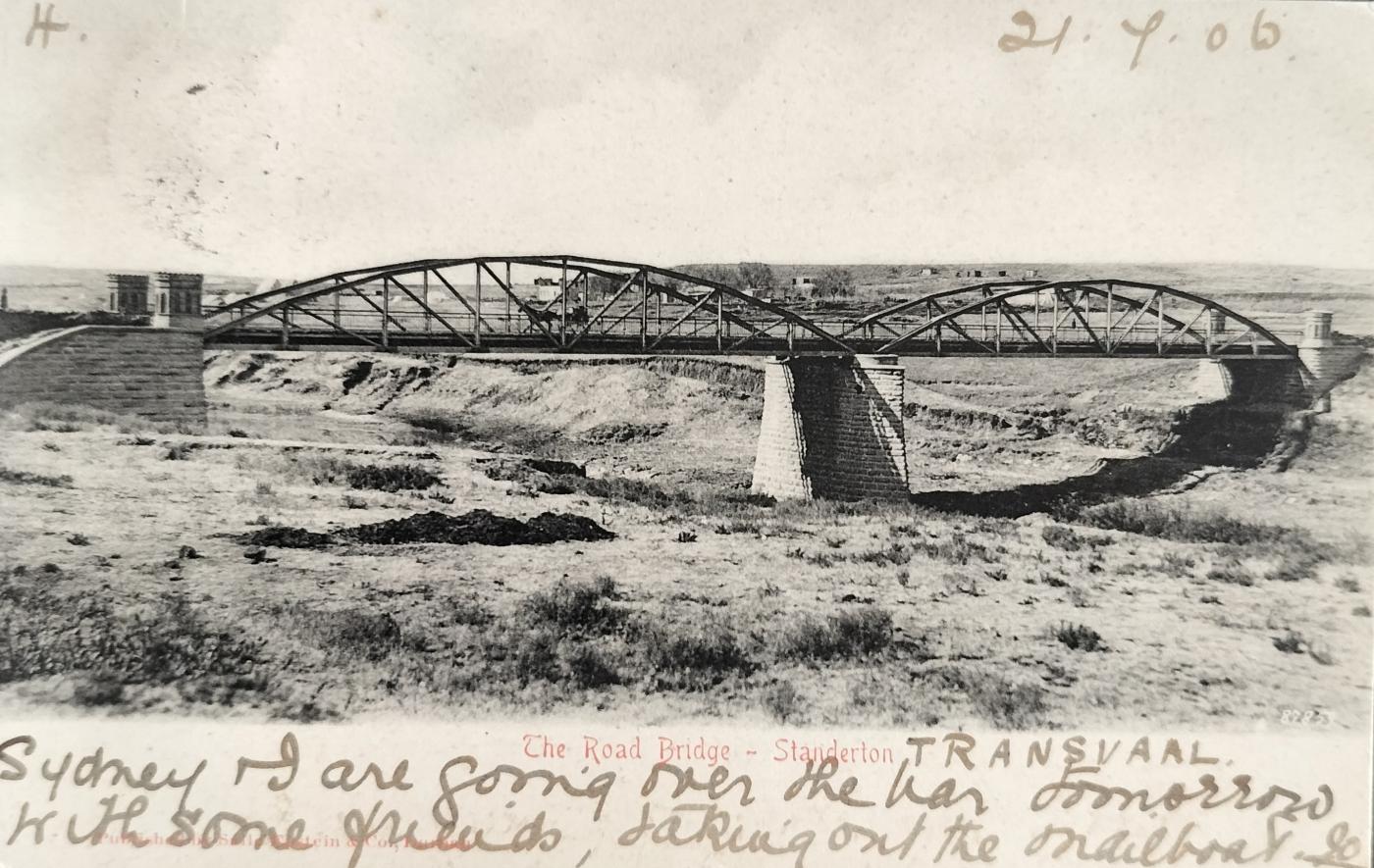
Kruger Bridge just outside Standerton. Due to their respect for the President, the Boers elected not to blow up this bridge during the Anglo-Boer War. The railway bridge did not receive the same treatment. Card published by Leonard Dingler from Standerton (circa 1905).
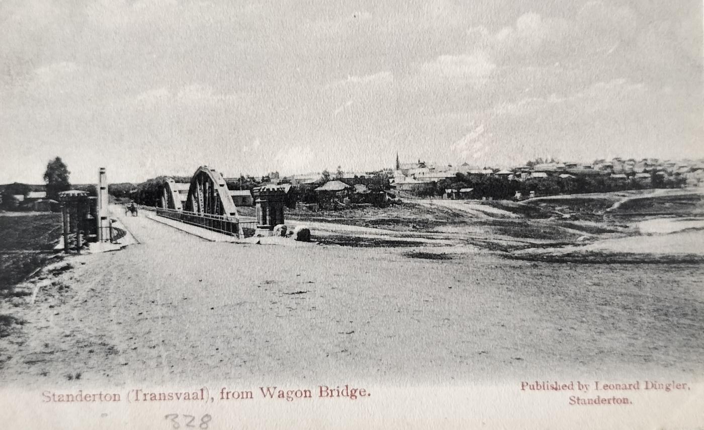
Another view of the Kruger road bridge in Standerton. Unnumbered card published by Sallo Epstein & Co (circa 1904)
8. Flood
Flooding in Standerton was not an uncommon occurrence.
Other than visual evidence, little information is available on the flood that occurred in January 1911. An Australian newspaper reported that the damage totalled £30,000 at the time with the loss of two hotels.
Although human lives were not threatened during this flood, in that the water was slow in rising, one young man, Adam Haupt, about to start his teaching career, drowned in attempting to assist his sister in removing furniture from her house.
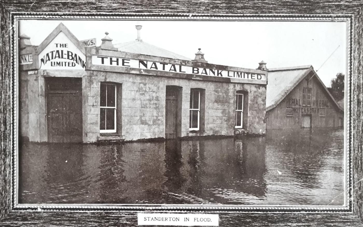
The Natal Bank and Imperial Mineral Works buildings during the 1911 floods. Card published by ML Greenblatt from Standerton.
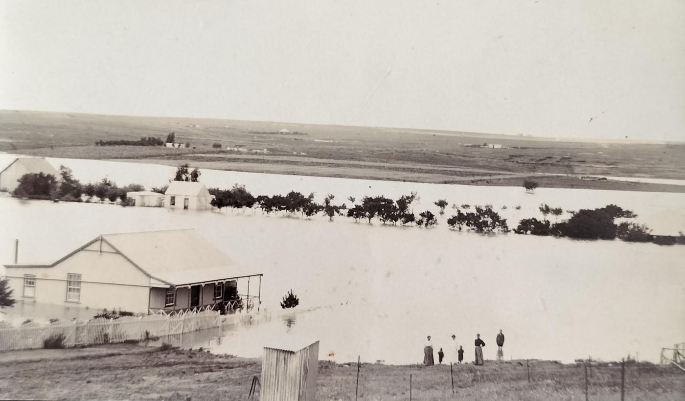
Four adults and two children posing for the camera during the 1911 Standerton floods. They were probably the occupants of the house on the left. The card contains no publisher details.
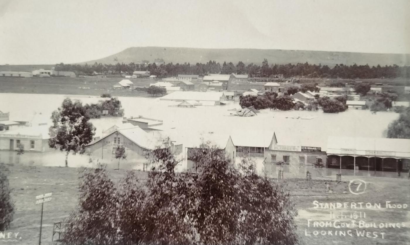
Panoramic view, with Stander Kop in the background, following the 1911 Standerton floods. The flooded building on the right is that of Cohen Brothers. On the left, the Natal Bank and Imperial Mineral Works buildings can be seen. The photograph was captured from a government building in town. The card, numbered 7, contains no publisher details.
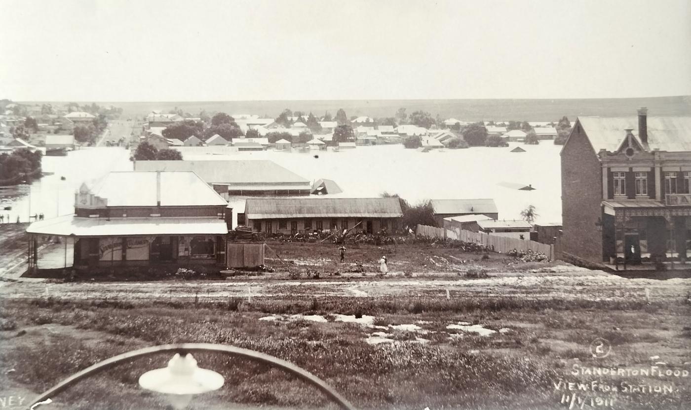
Card number 2 of the 1911 Standerton floods captured from the railway station. The building on the right is the old Railway Hotel. Just left of the hotel building, the rooftop of a house is barely sticking out. The shop on the left is the Standerton Creamery. The flooded Burger Street on the left of the creamery is clearly visible. The card contains no publisher details.
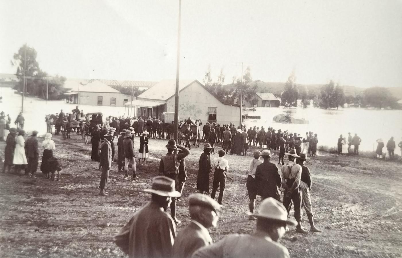
1911 Standerton floods. Residents looked on in disbelief. In the background, the railway bridge can be seen. The card contains no publisher details.
9. Anecdote of youthful entrepreneurship
Scholtz (1966) shares the following joyful anecdote:
Around 1916, the local town council, in an attempt to eradicate the annual worm plague that affected willow trees the worst, decided to pay one shilling per pound of worms presented to them.
Local primary school boys did not rest on their laurels and soon kicked off their worm collecting. So successful was this activity that within a few weeks the money fountain dried up for the boys in that all the worms had been successfully eradicated - from Standerton town at least.
This resulted in the boys becoming creative – they engaged boys from the surroundings (neighbouring farms and smaller towns) and offered them 6d per pound of worms delivered. These worms were then transported daily to Standerton town via train, horse, donkey cart or by foot. It was only a month down the line that the town council realised that they had been deceived by the young ’cheating’ entrepreneurs.
10. Postcard publishers
Without the earlier postcards published, we would not have had an idea as to what Standerton looked like.
Picture postcards of Standerton were produced by several publishers at a national level.
The two stand-out producers are the two Standerton businessmen Dingler and Greenblatt.
Whilst there was a strong presence of Greenblatt’s in early Standerton, little, if any information could be found about the publisher Greenblatt.
The story of Dingler however is an interesting one.
Leonard Dingler arrived in South Africa from Holland in 1904. With limited knowledge of the tobacco industry, he brought with him a small hand-cutting device to cut tobacco with the intent of following his dream of producing tobacco products in South Africa. He set up his first shop in Standerton in the same year.
The success of his first two products led to more brands being developed, and in 1908, when Dingler saw the potential of tobacco sales to the mines, he relocated the factory to Benoni.
Dingler clearly had an entrepreneurial spirit in that he also saw potential in publishing postcards. He in all probability did not capture the photographs himself but bought them either from local or traveling photographers.
The main market for these picture postcards at the time would have been the hundreds of soldiers stationed at or passing through the Standerton Cantonment (Military Barracks).
11. Standerton photographers
Without the creators of the picture postcard, the photographers, we would have been none the wiser as to what our towns looked like some 100 years ago. It is, therefore, important to also briefly reflect on the photographers who were active in Standerton.
It is suggested that the photographs for the postcards published by Dingler and Greenblatt may have been captured by mainly Hesselson and Reiff (the two longer-serving photographers in town).
At this point, it is not known when the first photographer settled in Standerton.
The Hardijzer Photographic Research Collection (HPRC) has identified the following photographers who were active in Standerton before 1915:
- Julius Hesselson – Burger Street (Russian). Jewish by birth (1877), he was also known as Yehuda ben Shraga. He tragically died at the young age of 43 on 11 February 1920. The cause of his death has been described as a train accident at Suikerbosrand Spruit near Heidelberg. His death certificate indicates that he was a general merchant/carriage builder. No reference is made to him being a photographer. At the time of his death, he was one of the leading members of the Standerton Jewry and held office as President of the Congregation. The Synagogue in Standerton was built as a fitting memory and tribute to Hesselson. The foundation stone of the Synagogue was laid on 1 August 1928. He married Ethel Hesselson (born Katzen) in Germany. The couple had three children, namely Gertie (born 1904), Mollie (1906), and Philip (1910).
Standerton street scene (Burger Street). Visible on this card is the James W Douglas bottle store as well as the J. Hesselson Photographic studio. Hesselson was also a carriage builder in town. He died young in a rail accident near Heidelberg (circa 1912)
General view over Standerton. Corner of Burger and Market Street with the railway bridge visible in distance. In the background (behind the trees) a few carriages can be seen. These stand at the carriage builder Hesselson’s factory. He also had a photographic studio in town. The publisher of the card was ML Greenblatt who was based in Standerton (circa 1908).
- David Mendel Reiff (Russian) – Born 1874, Reiff originates from Russia (Polangen). Initially attached to a studio in Rosenow, Germany, Reiff arrived in South Africa around 1893, aged 20, and soon joined the Johannesburg-based Goch Studio. Around 1901, Reiff was appointed to manage the Talba studio in Kimberley. While still in Kimberley, Reiff married 22-year-old Russian-born Lena Leven at the Kimberley Synagogue in October 1901. The couple soon relocated to Ermelo. Whilst residing in Ermelo, Lena lost her life due to heart failure, probably whilst giving birth to little Lena in April 1904. Little Lena also passed away 3 months later. While no birth information could be confirmed, the couple already had a daughter, Jessie. Reiff remarried in September 1911. He was still based in Ermelo at the time. His second wife, Esther Sale was also Lithuanian/Russian-born. Esther passed away in Bulawayo (Zimbabwe) in April 1968. The couple had 4 children, namely Ida, Joseph Isaac, Sybil, and Frederick Abraham. It is suggested that Reiff was active as a photographer in Standerton from the early 1910s to mid-1920s during which he was also described as a prominent member of the local Jewish Community.Later in life, he became a general dealer – seemingly in Bulawayo - Southern Rhodesia (Zimbabwe) where he passed away, aged 74, in September 1946.
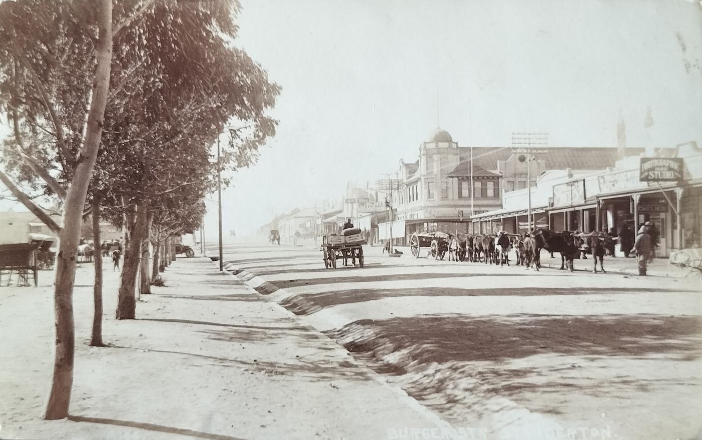
Standerton street scene (Burger Street) shows a photographic studio (probably Reiff’s studio), jeweller and watchmaker as well as the Landau & Co establishment (larger building). This real photo postcard was published by SAPSCO (circa 1910).
- Other photographers
- Robinson Christiaan Engelstoft Nissen (British) had a number of studios in South Africa, but eventually settled in Johannesburg. Nissen was also a news reporter during the Anglo-Boer War. He worked for Daily Mail, Central News, and Cape Times. It is also reported that he picked up the dreaded fever during this period. Nissen also happens to have been the mentor to Johannesburg’s first recorded female photographer, Sara Buijskes.
- Brothers Carl Gustaf and Christian Frederick Lund (Norwegian) who eventually settled in Kroonstad.
- G Payer
- FW Slack, thought to be Frederick William who was in business with Berning in Standerton (Berning & Slack)
- HJ Smith & Co.
- J Blom
- Taylor
Closing
Standerton also has a strong educational history which Scholtz (1966) has written about, from which I could make little sense.
The history presented above is by no means complete. There is no doubt in my mind that the historical information captured above can be refined and expanded on – It has to.
On a different topic. In three instances I have submitted some of my themed postcard collections to national philatelic competitions. In one instance, the collection received the highest possible accolade, but it still left me somewhat despondent. It was judged by mainly an international panel, but only seen by a very small audience. How can these specialised collections be made more accessible and visible? I stumbled upon the answer – through articles such as these. At least it results in permanency.
The postcard collection referred to above that achieved the top award (large gold) was on the ethnic population groups of the German South West Africa era (1895 – 1915).
The next article in this series will be on Volksrust, followed by towns such as Ermelo, Middelburg, Barberton, Lydenburg, Pilgrims Rest, and Pietersburg.
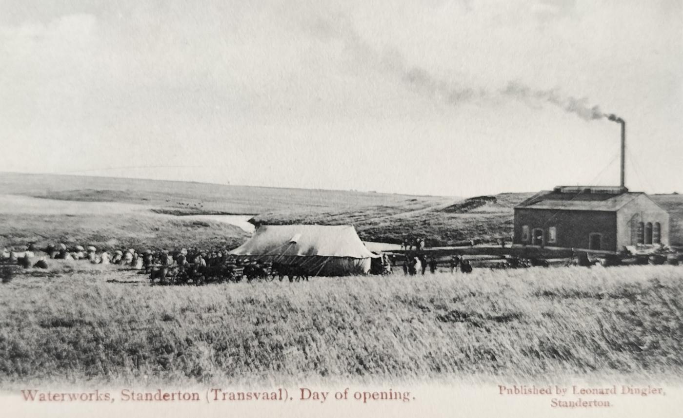
The day the Standerton waterworks opened (date unknown). Card published by Standerton resident Leonard Dingler (circa 1907).
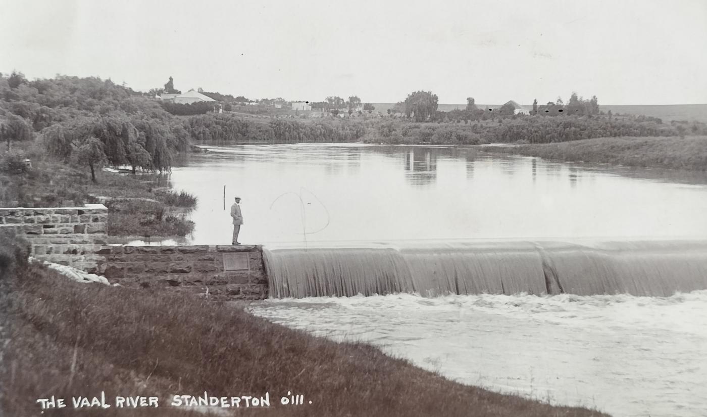
Vaal River running past Standerton. The publisher of this real picture postcard is SAPSCO (circa 1912).
About the author: Carol is passionate about South African Photographica – anything and everything to do with the history of photography. He not only collects anything relating to photography, but also extensively conducts research in this field. He has published a variety of articles on this topic and assisted a publisher and fellow researchers in the field. Of particular interest to Carol are historical South African photographs. He is conducting research on South African based photographers from before 1910. Carol has one of the largest private photographic collections in South Africa.
Sources:
- Biggins, D. (2022). Standerton. (www.angloboerwar.com)
- Fisher, R.C. & N.J. Clarke (extracted 15 November 2023). Road bridges of the ZAR – an annotated photo-essay. (repositories.tudelft.nl)
- Hardijzer, C.H. (2023). Early Heidelberg Through the Eyes of a Deltiologist. Forerunners. No 107 (Vol. XXXVI, No.3, September-December 2023)
- Hardijzer, C.H. (2023). Early Heidelberg Through the Eyes of a Deltiologist. (theheritageportal.co.za)
- Hardijzer, C.H. (2023). Pioneer diamond field photographers – Kimberley (1869 – 1915). (theheritageportal.co.za)
- Scholtz, P.G.M. (1966). Standerton – Gister en vandag. Bloemfontein Sentrale Pers
- Unknown (1900 – extracted 15 November 2023). Standerton Burghers surrender (trove.nla.gov.au/newspaper)
- Unknown. (nd – extracted 15 November 2023). NZASM – South Eastern Line Railway station (artefacts.co.za/main)
- Unknown. (nd – extracted 15 November 2023). NZASM – Standerton railways precinct. (dutchfootsteps.co.za)
- Unknown (extracted 15 November 2023). Gereformeerde Kerk Standerton. (af.wikipedia.org/wiki)
- Unknown (extracted 15 November 2023). NG Gemeente Standerton. (www.gemeentegeskiedenis.co.za)
- Unknown (extracted 15 November 2023). Joseph Lockwood Hall. (https://artefacts.co.za)
- Unknown (nd - extracted 14 November 2023). About Standerton (www.standerton.com)
- Unknown (nd – extracted 22 November 2023). Boervolk Erfnis Bewaring – Standerton.
- Unknown (extracted 26 November 2023). Road bridge over the Vaal River. (artefacts.co.za)
- Unknown (2020 – extracted 22 November 2023). Small Jewish Communities’ Association – SA (www.facebook.com)
- Van der Westhuizen, G. & Van der Westhuizen, E. (2013). Guide to the Anglo-Boer War in the Eastern Transvaal 1899-1902. (Revised edition). Privately published.
- Wesley, C. (2006). (www.wesleys.co.za). Dingler’s dream 1904. Across the Counter - Fortnightly Articles. "Conversations with Customers" (No 142 - June 1, 2006)
- Wikipedia (extracted 14 November 2023). Standerton (Wikipedia.org)
- Wikitree (Adriaan Hendrik Stander – extracted 14 November 2023)
- Wikipedia (extracted 25 December 2023). Standerton Commando (Wikipedia.org)