
When George Harrison discovered the Main Reef of gold at Langlaagte farm in 1886, it was believed by many to be an old river that had been turned on its side. They therefore believed the gold could not continue for more than about 30 to 50 meters underground.
That this was wrong was soon revealed by pioneers like J.B. Robinson who proving that the reef dipped far underground. The next theory was that this was a deep lake, that had filled with gold-bearing debris over the ages, from rivers entering at various points. However no such rivers or traces of them exist.
Another theory became popular, that the gold had come up in volcanic activity, the volcanoes being eroded away over time, and releasing gold rich rock into an inland sea. This view of how the Witwatersrand gold fields developed held sway until recently, when imagery from space became available.
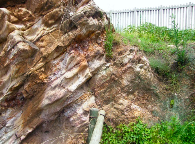
Portion of the Main Reef at George Harrison Park (Gavin Whitfield)
Before time
Before time was as we know it, a great inland sea or lake existed where today the Witwatersrand lies, and stretched out right across the Orange Free State.
Along the shoreline, mostly along what would become the Witwatersrand, but stretching away towards Potchefstroom, seemed to be a series of hot springs or geysers. There may also have been genuine volcanic lava vents, but at this early stage probably not.
These springs, heated to boiling far underground where water came into contact with hot rock in turn heated by lavas from the Rietfontein series of faults, carried iron-rich mud. These muds in turn were dense enough to lift with them various minerals, copper, silver, uranium and others, leaking out of the Earth’s center.
It is assumed that these hot springs vented in roughly a great semi-circle over a hundred and fifty kilometres. Some were bigger than others. Some carried little or no minerals. Some carried uranium in great quantities.
These geysers seemed seasonal. In times of rain as water reached the hot rock, they cracked the underlying rock, allowing sulphur, gold, iron rich mud, silver and uranium, to boil out in huge quantities, fanning out across the low lying ground to the South, and spreading their minerals as they spewed. These minerals, mixed with quartz rock and other debris, formed layers of iron-rich conglomerate. In dry seasons, the waters dried up and sand and dust blew and fell across the lake, or swamps. These quartz rich sands hardened under successive layers into the quartzite we know today.
So over the years the layers built up, one on top of another. Today this can be seen at the Roodepoort Botanical Gardens where a cliff face exposes these layers.
It would seem that this continued into the time of the dinosaurs, or other hard boned animals, as fossils of such bones have been discovered along the present Florida Ridge.
The impact
Then at a point in time, a huge meteor fell in the present district of Vredefort. It is reported by Professor Roger Gibson of the University of the Witwatersrand as having an impact equalling approximately 400,000 megatons of TNT.
This gigantic occurrence blasted a crater over 100 km wide and tens of km deep. It may in fact have been an ice-comet as no remains were found, the ice melting instantly under fantastically high temperatures. With the invention of the electron microscope, minute particles of meteor debris were identified, providing evidence of the massive impact event.
Looking at the impact site from space it is clear that the Witwatersrand was formed as part of this impact. The semi-circular shape of the Wits ridge forming an outer rim of the crater.
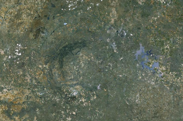
Vredefort Dome Central Uplift (Google Earth)
That the meteor came in at an angle, from the South, is demonstrated by the Witwatersrand ridge being most disturbed and deformed, to the North of impact. This will also explain why some of the gold mines in the Randfontein area had stopes that were vertical.
That the impact caused the lake, or multi-layered swamp, to distort is obvious. The gold and mineral rich layers were displaced downwards like the saucer of a cup, the ‘hinge, being along the Witwatersrand ridge and sloping downwards at angles around 30 degrees at surface and curving out as deep as six km underground.
This impact may have given the Earth its off-set, and caused a dust-storm that may have lasted up to three years.
The Lavas
At impact the meteor certainly penetrated deep enough to open and allow magma far underground to escape in places. These lavas were found in many places while gold-mining.
Surface occurrences
On the surface, a huge tidal-wave or Tsunami screamed northwards, taking the tops of the volcanic vents, or pipes, with it. This piled up along a roughly East-West line to form the Witwatersrand Ridge, about 120 kilometres from impact.
Today if one studies the formation of the ground between the Main Reef and the Witwatersrand Ridge, one realises that the ground slopes gradually up, then drops dramatically, over the Ridge, in fact there are two ridges in most places, this becoming more extreme towards Krugersdorp and Randfontein.
The tops of the pipes were transported Northwards with the debris and came to rest along the Wits Ridge, mostly along the Southernmost, North-facing, ridge.
Chemistry
Coming up from deep underground were sulphurs common to volcanic vents, and iron rich muds, along with the elements already mentioned, such as gold, silver et al. (it should be noted that we do not know for certain the exact compounds or contaminants being brought up in the springs).
With my limited knowledge of chemistry, I presume that: The boiling water coming into contact with the sulphur formed a dilute sulphuric acid and hydrogen gas.
When the meteor struck, the temperature was raised to thousands of degrees C.
This probably caused a double reaction, the dilute sulphuric acid reacting with the iron mud to form Ferrous Oxide and hydrogen.
Ferrous Sulphate plus hydrogen.
And again under tremendous heat, this split into Iron Pyrite and water.
Iron pyrite and water. The water would have boiled off instantly.
Today, masses of iron pyrite is (or was) mixed in with the gold. So much so that early gold-separation over copper plates covered in Mercury could not separate it and almost caused the mining on the Witwatersrand to shut down.
Could this have been the source of the Iron Pyrite?
Pioneers
When the Struben brothers, Fred and Harry, began prospecting the Witwatersrand ridge around 1883-4, they found gold in small quantities in the streams and quartzes. When Fred Struben discovered the “Confidence Reef, he states in his diary “ I was finding a grain of gold for every grain of sand”. (Fred Struben diaries, University of the Witwatersrand, and Oppenheimer Library.)
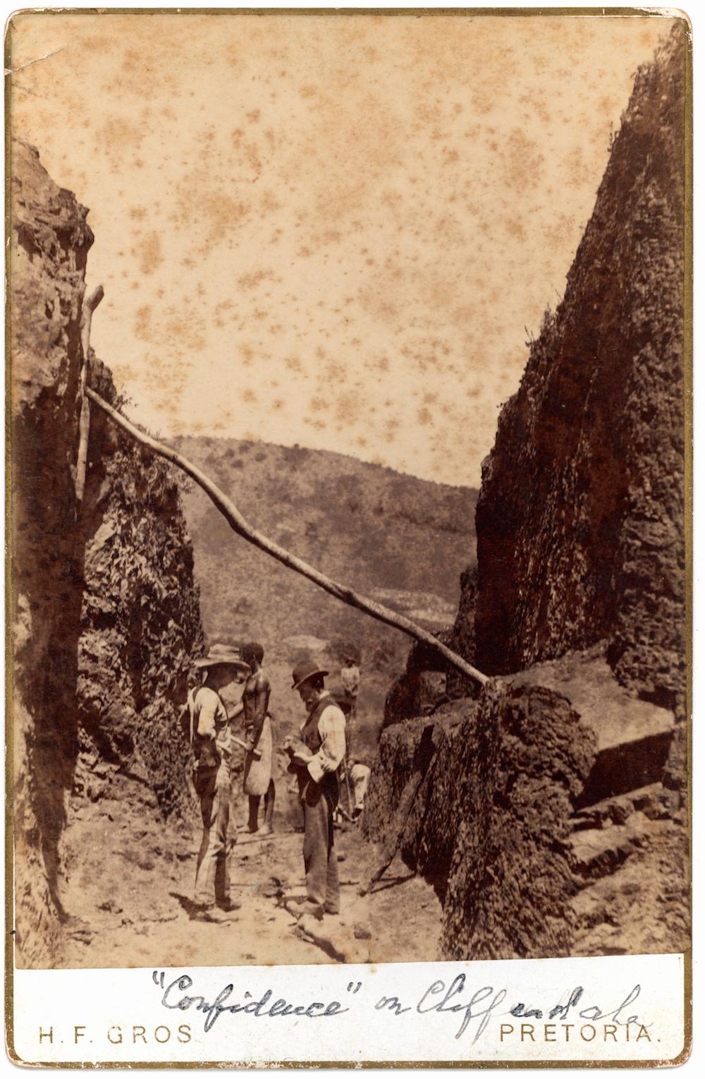
Confidence Reef Mine (H F Gros)
Over the years, many other men tried mining into the Witwatersrand ridge, notably George Brown and the French Count De Waru. All found gold on the surface, but it petered out at about 30 meters, and almost all dipped towards the South.
Fred Struben states in his diary, “I was chasing a pipe, but lost it and could not find it again.”
If my conclusions are correct, what Fred Struben and others found, was the tops of the vents or springs, displaced North by the meteor impact, and sheared off from the parent pipes.
Iron rich slates
Today there are considerable amounts of iron-rich muds or shale laying along the Wits. Ridge, stretching from Krugersdorp through Kloofendal and the Melville Koppies. This appears to be the unchanged remnants of the muds brought up by the hot springs, yet too distant from the impact to have suffered chemical change.
Conclusion
It is therefore probable, that these pipes still exist, North of the Main Reef, and that there existence was never suspected by early miners, concerned only in mining on the Main Reef series, which dipped South away from the probable pipes.
Therefor there should be big pipes in the Johannesburg and Langlaagte areas, as well as others ranging along the line of the Main Reef, but North of it. That it may be impossible to discover the Johannesburg pipe is obvious, with the City built on top of it.
It lies with future prospectors to prove or disprove these pipes.
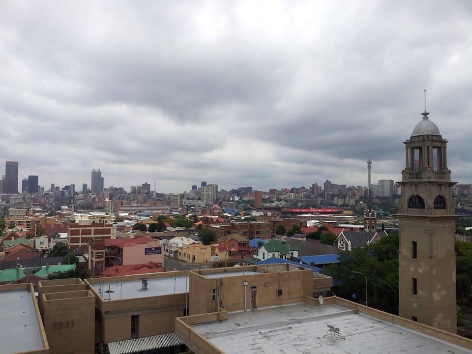
The City is built on top of the Johannesburg pipe (The Heritage Portal)
References
- The Strubens and Gold, by Anna Cunningham, Wits University.
- The University of the Witwatersrand, William Cullen Library.
- University of Johannesburg, School of Mining, Library.
- The Oppenheimer Library.
- Florida Public Library.
- Meteorite Impact, by W.U. Reimold and R.L. Gibson, Wits University.
- Randfontein Estates, by Anthony Hocking.
- Goldfields Revisited, by Edward p. Mathers, F.R.G.S.
- Many other books on early Johannesburg.
- Recollections of Adventures, by Harry Struben.
- The Fred Struben diaries, at Wits University and the Oppenheimer Library.
- Google Earth.
- My own observations on the ground, on my own and while guiding tourists, and researching this paper.