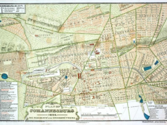
In 1896 Johannesburg had reached its tenth birthday. The astounding growth of the town in its first decade meant that the authorities (at that stage It was the Johannesburg Gezondheids Comite or the Sanitary Board / Committee) wanted to know about the population of the town, its origins, location, composition, religions, local industries and occupations. The Sanitary Committee decided that a census of Johannesburg and its suburbs, within a three mile radius from the Market Square should be taken to capture accurate statistics to plan ahead for the needs of the new town. They wished to address issues of sewerage, drainage, property assessment rates in “a progressive town like Johannesburg”.
Market Square circa 1892 (Davies Brothers)
Census Essentials
The Census was conducted on 15th July 1896 under AH Bleksley, the Director of Census. The report was published some two months later on 15th September. It is a substantial document of many fold out pages of tables. The printing was undertaken by the Standard and Diggers’ News in Johannesburg. It is an extraordinary report because it is sophisticated, meticulous and detailed in the tabulations. The report opens up a window on early Johannesburg from an entirely different angle. The Sanitary Committee had to deal with a problem of jurisdiction and coverage; Johannesburg comprised the area administered by the Sanitary Committee and their authority extended...
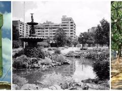
Irving Lissoos earns his living as a highly respected, specialist urologist. He consults and operates from Milpark Hospital. But his life embraces other enthusiasms, among them a love of Johannesburg, partially illustrated by his membership of the Parktown and Westcliff Heritage Trust. Lissoos’s guided tours through Joburg’s old cemeteries in Braamfontein and Brixton are always sell outs. Lissoos lives in Victory Park. He grew up in Berea, attended Yeoville Boys’ and King Edward’s schools. I arrived in his rooms one day armed with a tape recorder and one or two simple questions, asking him to talk about his early life. Nothing had been planned. He quite spontaneously and easily advanced down ‘memory lane.’ He told me with many chuckles and obvious reminiscent enjoyment, about a social existence, the world of his childhood and youth, which no longer exists:
Braamfontein Cemetery (The Heritage Portal)
‘My mom was born in London. Her father was a cabinet maker who came to Johannesburg just after the turn of the 20th century. She went to school in London but never got a chance to...
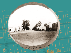
The town of Calvinia is situated south of the Hantam mountains. The name connects it to the early inhabitants of the area, the Khoekhoen, who probably called the place Hantam due to the abundance of the plant Pelargonium biflorium, which they called Heyntama.
The first colonists arrived in the 1740s. The farm Ackkerendam (now the nature reserve to the north of the town) was granted to Jan Otto Diedriks on the 24th December 1750. In 1763 it was transferred to Adriaan van Zyl, who passed it to his niece’s husband, Abraham van Wyk. The van Wyks later occupied the adjacent farm Hoog Kraal and in 1847 a section was sold to The Church Wardens of the Dutch Reformed Church at Hantam, the original name of the village. The first minister changed the name to Calvinia after the Protestant reformer, John Calvin.
The surveyor, J Knobel, laid out water erven from the centre of the town towards the Oorlogskloof River. These were watered from a spring at the western end of Water Street that led into a furrow that crossed these plots. On the other side of the long church square were dry erven. Later, the streets alongside the square were named Water Street to the south and Hope Street to the north.
The Census of the Cape Colony of 1865 showed the increases in occupations for the Clanwilliam District, of which Clanwilliam and Calvinia were the principle towns. From 1856 to 1865 those engaged in agriculture grew in numbers from...
On Saturday 16th February, Chinatown in Cyrildene put on its festive finery and glamour costumes. The colour red predominated and red symbolises happiness. The Chinatown in Cyrildene was celebrating the Chinese New Year in style with the biggest and best of street parties.
As the sun began to drop over Cyrildene, the ladies in red marched with cymbals and drums. (Mark Straw)
The celebration is a harbinger of good luck and a happy year ahead for the residents, shopkeepers, neighbours, spectators and friends. It was a special event that highlights that Chinese culture is a vibrant part of Johannesburg and that Chinese customs, myths, beliefs and celebrations are now a part of the city’s heritage. Culture and heritage are for sharing. In China the new year festivities, which extend over a month from January to February, are also called the Spring Festival.
[[{"fid":"7591","view_mode":"media_adaptive","fields":{"format":"media_adaptive","field_file_image_alt_text[und][0][value]":false,"field_file_image_title_text[und][0][value]":"Fireworks at Chinese New Year in Cyrildene - Mark Straw - 2019"},"link_text":null,"type":"media","field_deltas":{"3":{"format":"media_adaptive","field_file_image_alt_text[und][0][value]":false,"field_file_image_title_text[und][0][value]":"Fireworks at Chinese New Year in Cyrildene - Mark Straw...
In the article below, journalist Lucille Davie reveals some of the forgotten and fascinating history of the Johannesburg suburb of Linden. The piece was originally published on the City of Joburg's website on 14 September 2004. Click here to view more of Davie's work.
Peach and cherry orchards, fields of maize, chicken farms, a large dairy . . . Sound way out in the country? It wasn't. This nature lover's paradise existed in Linden in the 1920s, and you can read all about it in Tim Truluck's Historical Map of Linden.
This is Truluck's second fold-out brochure - the first was on Parkhurst - and meticulous research has obviously gone into this history, tracing Linden's history from its earliest beginnings in 1899.
Truluck plans to research the history of all Joburg's suburbs, eventually producing a book.
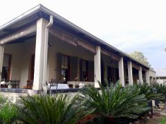
The suburb was named after Johannes Jacobus Rabie van der Linde, a farmer from Philippolis in the Free State. He co-owned the south western corner of the farm Klipfontein with Louw Geldenhuys, who farmed fruit and vegetables on the neighbouring farm of Braamfontein.
Stoep of the original farmhouse in 2nd Avenue Linden (Lucille Davie)
They both bought their portions of the farm in 1896 but...
In the article below, journalist Lucille Davie reveals the rich history of Lonehill in Sandton. She also uncovers some wonderful details about the places, spaces and people of Sandton before it became the financial capital of South Africa. The piece first appeared on the City of Joburg's website on 25 February 2003. Click here to view more of Davie's work.
There’s a story that if the top boulder of the Lonehill Koppie were dislodged, all the whites in the country would leave. It’s a latter-day version of an Anglo Boer War tale: that if the Boers dislodged the rock, the British would lose the war and leave South Africa.
Whatever version you fancy, the top boulder, which balances on several larger boulders, is still firmly in place and although some whites have emigrated, most are just as firmly still in the country.
Ladder to the top (The Heritage Portal)
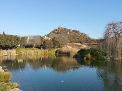
The Lonehill Koppie is beautiful – it stands out as a lone koppie in the middle of suburbia, some 28 kilometres north of the city centre, and is a reminder of what Johannesburg used to look like before it was settled: rocky veld with small streams trickling through it, dotted with shrubs, small trees and knee-high grasses. Guinea fowl...
Dube is the name of a popular township in Soweto, but on a larger scale Dube is a well-known Nguni surname. However, in nature the name belongs to an animal, e-dube – a lovely, cheeky one with bold black and white stripes, the zebra. Here follows an exploration of the story of the Dube Township, Soweto’s own zebra. It is bound to reveal a few secrets and highlights how the Dube history differs from that of other Soweto townships. There are however, also similarities and a common apartheid and struggle past.
The Dube Township’s journey begins in 1946, the year in which the Johannesburg City Council (JCC) had a dream to create a middle class African village. For this a portion of land adjacent to the first townships like Orlando West and Jabavu on the Klipspruit farm was identified. Since 1946 was the year in which John Langalibalele Dube – a popular and outstanding African leader with a remarkable history – died, his memory was honoured by naming the hope for a better living dispensation after him. However, the dream had many nightmares before Dube became a township in 1954 – the eventual product a watered down dream, yet an integral and special part of Soweto.
John Dube
Of course in 1946 and 1954 the name Soweto was not yet in existence and areas for...
Heritage encompasses all that we experience in everyday life. It is far more fluid in how it is experienced by society than what we perceive it to be. It is where ideas of individual identity and the role of nation states connect. It is who we are as individuals and how we relate to one another in society.
“In one familiar aspect it, it refers to buildings, monuments, landscapes and artefacts; but it can also refer to values held in common, bodies of memory, even personality traits. The National Heritage Resources Act No. 25 of 1999 specifically refers to a category of ‘living heritage,’ which includes such phenomena as cultural tradition, oral history, performance, ritual, popular memory and ‘indigenous knowledge system." (Shepherd, 2008)
In order to be able to decipher the complexities of our heritage one has to first delve into the history of how we came to experience heritage as we do today. In so doing we seek to find the path that leads to a more inclusive and representative society that we all subscribe to in all its diversity. The National Heritage Resources Act No. 25 of 1999 set out with the aims of stitching together the disparate strands of all society in order to forge a path for the rainbow nation.
Nearly twenty years on it has become apparent that there is a need to revisit and assess how far we are from achieving the goals that the Act sets out in order for us to meet the challenges that...
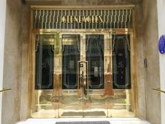
Killarney is one of the great historic suburbs of Johannesburg. With its majestic buildings from different eras, there is a great case for it to be declared a heritage area. The article below, written by journalist Lucille Davie, is packed with fascinating details on the people, history and architecture of a majestic neighbourhood. The piece was originally published on the City of Joburg's website on 18 January 2012. Click here to view more of Davie's work.
Running a bath in a flat in Gleneagles is more than just filling up a tub – the hot water goes via a stainless steel towel rack attached to the wall, heating it before the water reaches the bath.
Gleneagles, an art deco building in Killarney, has just been given a blue and white Egoli Heritage Foundation heritage plaque. It is one of several art deco blocks in the suburb – Mentone Court, Killarney Mansions and Daventry Court are other outstanding examples of the style.
Gleneagles Blue Plaque (The Heritage Portal)
Gleneagles (The Heritage Portal)
Besides the towel rack, Gleneagles bathrooms make bathing a stylish affair: a decorative metal laundry basket alongside the rack...
Cultural history is plagued by the plague. The Black Death stalks through history pages captivating and horrifying us at the same time, even Shakespeare used the threat of the plague in his plays to curse his characters. Most modern humans see the plague as something of the past, a historical disease far removed from modern day living and experience.
However the plague has once again raised its head.
In October 2017 the World Heath Organisation issued a warning to nine countries including South Africa that they were at risk of contracting the plague through trade with Madagascar which had lost 124 people to the Yersina pestis bacteria by the 26th of October 2017.
This warning and the slew of news articles written about the potential outbreak reminded me of some research I had done a few years ago about early Johannesburg.
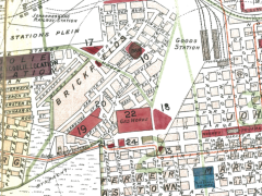
In 2013 and 2014 Newtown Junction was being built. At the time I was asked to be involved in the building process as the excavators had been digging up a great deal of artefacts. I went along to the site and was greeted with a stratigraphic column containing a 30 cm layer of what looked like glass glued together with ash. It looked like something you would expect to find near a volcano or at the sight of a devastating fire.
I had to know what happened.
[[{"fid":"1348","view_mode":"media_adaptive","fields":{"format":"media_adaptive","field_file_image_alt_text[und][0][value]":false,"field_file_image_title_text[und][0][value]":"Excavations for Newtown Junction - Heritage Portal - October 2012"},"type":"media","field_deltas":{"8":{"format":"media_adaptive","field_file_image_alt_text[und][0][value]":false,"field_file_image_title_text[und][0][value]":"Excavations for Newtown Junction - Heritage Portal - October 2012"}},"link_text":null,"attributes":{"title":"Excavations for Newtown Junction - Heritage...