
Plattekloof Pass was the second oldest mountain pass in the Langeberg/Outeniqua mountain range used by European traders, travellers and farmers crossing from the southern coastal plains to Kannaland. Situated north of Riversdale and Heidelberg in the Southern Cape, it was in use from the early 1700s until 1841 when it was replaced by the Gysmanshoek Pass. Thereafter Plattekloof Pass fell into complete disuse, so much so that it was soon forgotten. From the 1960s up to the present day, several travel and history writers allege that Gysmanshoek Pass was built on the route of the old Plattekloof Pass, this in spite of the fact that there was some evidence that the Plattekloof Pass had been west of the Plattekloof River, a branch of the Duivenhoks River, while Gysmanshoek Pass is east of the river. Based on the history of construction of mountain passes in South Africa, records kept by 18th century travellers, the topography of the area and Google Earth views, and a report by researchers from BartoIomeu Dias Museum in Mossel Bay, the author shows that Plattekloof Pass and Gysmanshoek Pass are two separate passes. The first follows a route over the mountain west of the Plattekloof River, the latter is east of the river. Both are of historical significance, and add to the interesting history of the Southern Cape.
1. Introduction
Attaquaskloof Pass north of Mossel Bay is the oldest mountain pass in the Langeberg/Outeniqua range used by European travellers to travel from the coastal plains to the hinterland. In 1689 Isaac Schrijver travelled through Attaquaskloof with his wagons to trade with the Attaqua tribe who had moved across the mountain into Kannaland (the Little Karoo). Attaquaskloof was the most important crossing over the Langeberg and Outeniqua Mountains for European traders, explorers and farmers, and was in use for 180 years until 1869 when it was replaced by the Robinson Pass (Bell-Cross & Venter, 1991).
Plattekloof Pass in the Langeberg Mountains north of the towns of Riversdale and Heidelberg in the Southern Cape was the second oldest mountain pass used by European travellers and traders crossing the Langeberg-Outeniqua mountain range from the southern coastal plain to Kannaland. Like most other old mountain passes, the pass was originally an elephant path and game trail across the mountains, and was used extensively by the hunter-gatherer Bushmen on hunting trips; later the local Khoekhoen pastoralists, the Hessequa, herded their cattle and sheep across the pass to grazing areas north and south of the mountains (De Jongh, 2016).
It is not known when Plattekloof Pass was first used by European travellers. It was a relatively easy way across the mountains (it took about 3 hours to cross by ox-wagon compared to Attaquaskloof which could take a day or more), and it can be assumed that it could possibly have been in use since the late 1600s, or at least from the early 1700s. The first recorded reference to the pass by a traveller was by Carl Thunberg who crossed from north to south in 1772, but most authors mention that the pass was in use from at least the 1740s. However, the farm at the southern entrance to the pass was established in 1727 when grazing rights for “Over de Duivenhoks Rivier aan de Plattekloof” was granted to Jurgen Potgieter (Van Wyk, Frans, 1988). In 1731 the grazing rights were transferred to Theuns Botha of Tulbagh, and in 1740 his son-in-law, Johann Andries Holtzhausen took over the grazing rights and moved to the farm where he built a simple 3-roomed house, this was later expanded into the magnificent old farmhouse still in use today (Pretorius, 2004).
It is possible that the pass was used by traders before farms were established in the area, in particular because it is a visibly low area in the mountain range and from afar appears to be a relatively easy route over the mountains. However, it is separated from the main route from the Cape to the east, De Groote Wagen Weg, by a range of high hills to the south, and cut off from Grootvadersbosch to the west by the deep ravines of the Duivenhoks River. The most accessible route from De Groote Wagen Weg branched off in the Spiegelsrivier area, or further east at Holbak and Kragga, and then across the range of hills now named (from west to east) Ertjiesvlei se Berg, Grootberg and Amandelbosberg, to the Plattekloof valley (Fig 1).
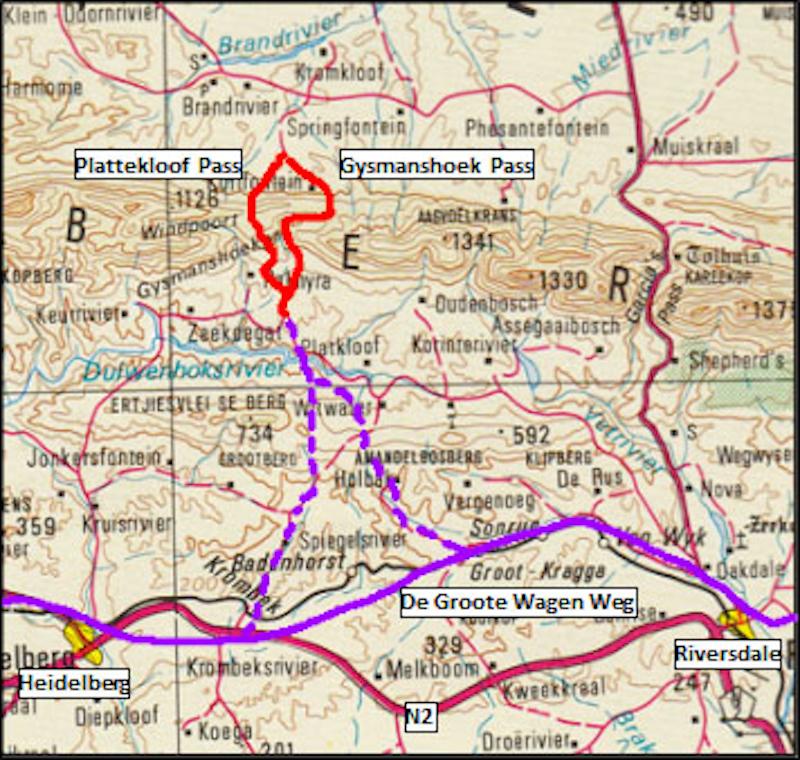
Figure 1: Map of region showing position of Plattekloof and Gysmanshoek Passes north of Heidelberg and Riversdale. The approximate route of De Groote Wagen Weg is shown in purple, with the routes from the latter over the hills to the Plattekloof valley in purple dotted lines.
Today the Gysmanshoek Pass crosses the Langeberg from the south over into Kannaland (Fig 2). The pass was first constructed in 1841, with a re-alignment in 1860 to avoid a steep section – the older portion can be seen higher up the hill where the pass cuts along the eastern side of the deep kloof formed by the Plattekloof River (Fig 3). After the re-alignment it was named the Hudson Pass, after J.F. Hudson who was mayor of Riversdale for two separate terms during the 1850s, at the end of his second term of office in 1861, he moved to Mossel Bay and later represented the town in the Cape Parliament. The name Hudson Pass did not appeal to the locals who continued calling it the Gysmanshoek Pass.
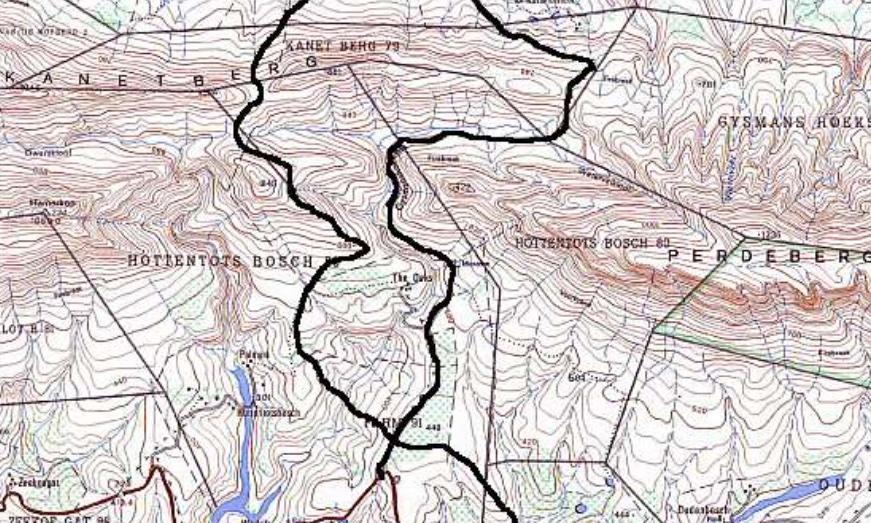
Figure 2: Routes of the Plattekloof Pass (left) and the Gysmanshoek Pass (right) over the Kanetberg in the Langeberg range.
In most books and articles about these mountain passes, it is assumed that Gysmanshoek Pass is built on the route of the old Plattekloof Pass. Burman (1981) describes the present Gysmanshoek Pass as being close to and parallel with the original Plattekloof Pass, both east of the Plattekloof River. However, Forbes (1986) writes about an old disused track to the west of the Plattekloof River, and the less steep Gysmanshoek Pass to the east of the river now in use.
Two publications about the history of Riversdale, Carina Erasmus’ Die Geskiedenis van Riversdal 1838- 1900 (1987), and Frans van Wyk’s Riversdal 1838-1988 (1988), both state in no uncertain terms that the Gysmanshoek Pass was originally the Plattekloof Pass. Referring to Maurice Garcia’s opening the route through the mountain along the Vette River (where Garcia’s Pass was built a few years later), Van Wyk (1988) writes: “Thus far (1868) the only road over the mountains was the Plattekloof Pass which appeared on Burchell’s map of 1772. The old pass which is currently still negotiable, ..., is also known as the Gysmanshoek Pass.” (Translated from Afrikaans). Both Erasmus and Van Wyk base their assumptions on the existence of the old pre-1860 section of the Gysmanshoek Pass that is still visible on the eastern side of the Plattekloof River. This assumption has been repeated as a fact in several other publications about Riversdale and district, as well as in publications of mountain passes, including the online Mountain Passes of South Africa (2016), and Marion Whitehead’s 2018 book, South Africa’s Favourite Passes and Poorts.
In 1991 the Bartolomeo Diaz Museum in Mossel Bay arranged a special exhibit on the mountain passes of the Langeberg and Outeniqua mountains. The research done for the preparation of this exhibition was published in an internal report by Dr Graham Bell-Cross and Jansie Venter (1991); in this report they state quite unequivocally that the route of the Plattekloof Pass was over the hill on the western side of the Plattekloof River, adding that “It is possible today to follow the original Plattekloof Pass right over the mountains”.
In this article I present evidence that the old route of the Plattekloof Pass was not the current route of the Gysmanshoek Pass, but crossed the Langeberg west of the Gysmanshoek Pass. While most of the evidence in support of this was stated by Bell-Cross and Venter (1991), we now also have the benefit of Google Earth imagery to support this premise.
2. The case for a separate route for Plattekloof Pass
2.1 Old passes on animal trails
Several publications refer to the fact that many mountain passes were originally animal trails, in many cases elephant paths, across the mountains which were used for hundreds of thousands of years by Homo habilis, Homo erectus, and more recently Homo sapiens as hunting routes (Mountain Passes of South Africa, 2016). During the last 2,000 years Khoekhoen pastoralists used these passes to cross the mountains with their cattle and sheep to grazing areas on either side of the southern mountain range. When the Dutch East India Company (the “Vereenigde Oost-Indische Compangnie” (VOC)) established a provisioning station at the Cape in 1652, they sent traders to buy cattle and sheep from the Khoekhoen; the traders soon followed the Khoekhoen across the mountains, followed in time by explorers, adventurers and later farmers (De Jongh, 2016).
The traders used ox-wagons for carrying their trading goods, mostly copper, beads, tobacco, woven materials, etc. At night stops they would usually sleep on or under the wagons, in later years when there were established farms along the way the travellers would stay with farmers on their route, trading with the farmers for fresh produce for their journey.
Animal paths usually approached the summit of the mountains along the spines of foothills leading to the top, the animals avoided walking laterally along steep slopes, preferring to go straight up and down the slope. Another feature of animal tracks is that while large animals can climb up quite steep slopes, they prefer a more gradual descent – this means that there are often multiple routes up and down either side of the summit of the pass. Oxen could easily use these pathways, and all that was necessary to accommodate wagons was to widen the paths, usually just by moving larger rocks and boulders out of the way. When a track became eroded and difficult to traverse, they simply moved to an adjacent path, or created a new track next to the old one.
2.2 Constructed passes – only after 1825
The first constructed mountain pass in South Africa was the Franschhoek Pass which was completed by Major William Holloway in 1825. This was the first pass where the hillside was excavated and a retaining wall built to create a level road surface (Mountain Passes of South Africa, 2016). Building passes like this became essential as horse-drawn carts and wagons were increasingly replacing ox- wagons for transporting goods over long distances. Horses or mules could not pull wagons up the steep slopes used by ox-wagons, but an advantage was that they could traverse much tighter corners. This meant that the incline of the constructed passes were at most 1:6, more often 1:8. Horses were also easier to maintain and feed along the route, and of course much faster, than oxen.
The increased use of horses and mules for long distance goods hauling was one of the reasons for the explosion of road and pass-building projects in the Cape Colony during the mid 1800s, projects mostly led by Andrew Geddes Bain and later his son Thomas Bain. The expansion of the postal service by the British Colonial government in the 1830s required improved roads and routes over the mountains. However, ox-wagons were still used for heavy haulage in rural areas into the early 1900s before being replaced by petrol driven vehicles.
By the late 1830s the condition of the Plattekloof Pass, which followed the old animal trail and path used by hunters and pastoralists had deteriorated so badly that it could hardly be used. Horse-drawn wagons and carts could not use it at all. In 1841 the Colonial Government granted £220 to “improve Plattekloof Pass”, this was later supplemented by a further £70 (Van Wyk, 1988).
The Gysmanshoek Pass was constructed in 1841 (Erasmus, 1987). Access from the south was along fairly level ground, but the route through the kloof formed by the Plattekloof River was constructed by levelling the roadway using a retaining wall and cutting into the hillside. This was done on the steeper upper roadway, the road many people refer to as the old Plattekloof Pass. But such techniques were not used before 1825, so this could not have been the Plattekloof Pass – the slope was also too steep for ox-wagons to traverse laterally without a levelled road surface, the wagons would simply have rolled over (Fig 3).
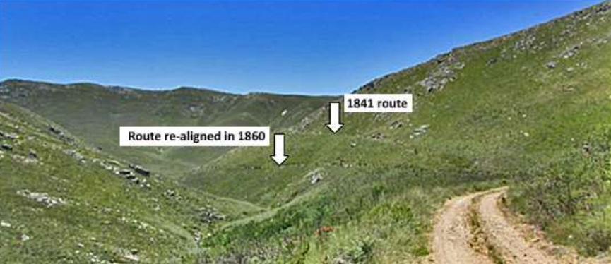
Figure 3: Gysmanshoek Pass with the 1841 route (upper arrow) above the current pass which was re-aligned in 1860 (lower arrow). Note the steepness of the slopes and the narrow gorge of the Plattekloof River – too steep and narrow for ox wagons to traverse easily.
I am convinced that the 1841 construction created a new route along the east bank of the Plattekloof River, there are no signs that the new pass-building techniques then in use were applied to the old Plattekloof Pass route. I think that the pass builders simply transferred the name Plattekloof to the new pass, it started from the same road in the south, took the traveller over the mountain, and completely replaced the old pass. However, the eastern end of the valley was on the farm Gysmanshoek, and it could very well be that this portion of the pass was first known as Gysmanshoek Pass, the name subsequently being applied to the whole route through the mountain. The 1860 realignment of a middle section of the pass was most likely to eliminate the rather steep northern slope into the valley of the Plattekloof River (Fig 3).
In some publications the older upper disused roadway is erroneously referred to as the Plattekloof Pass, and the current lower road is the Gysmanshoek Pass. The caption to a photograph similar to Figure 3 in Frans van Wyk’s 1988 book describes this as the old Plattekloof Pass with the lower road being the work done in 1841.
2.3 Travellers’ Tales
The entries made by Robert Jacob Gordon and William Paterson in their respective journals of their 1777 expedition into the hinterland of the Cape Colony provides interesting descriptions of their crossing the mountain over the Plattekloof Pass (Raper & Boucher, 1988; and Forbes & Rourke, 1980 respectively). They left Grootvadersbosch on 25 October 1777 and travelled a direct route on horseback, probably over Ertjiesvlei se Berg, to the farm Plattekloof where they stayed over with the Holtzhausens (son of Johann Andries Holtzhausen) until their wagons arrived a few days later. The wagons had to take a longer route, presumably along De Groote Wagen Weg and then crossing the Amandelbos hills from Spiegelsrivier or Holbak. On 28 October they left the farm and crossed over into Kannaland – Gordon states that “one can go from one side to the other in about two-and-a-half-hours”, Paterson states: “After three hours travel we gained the summit, where we had an extensive view of the country and the Indian Ocean to the southward and the Kanaland to the north and N.E.” (Forbes & Rourke, 1980).
Gordon writes: “We went up the mountain on the right hand from where we could clearly see the sea at a distance of about twelve hours S of us, and (realized) that the fiscal Cloppenburg’s map is not correct, since it shows the coast receding too rapidly to the N, and the Swartberg completely wrong. I drew the whole of Canna Land, with the Swartberg and other mountains.” (Raper & Boucher, 1988).
The important point here is that both Gordon and Paterson mentioned they could see the sea to the south from the summit. Looking at the topography of the area, a view of the sea is only possible from the hill to the west of the Plattekloof River kloof. Nowhere along the current Gysmanshoek Pass is a view of the sea possible, not even along the original higher route on the eastern side of the kloof. From where Gysmanshoek now crosses over the mountain into Kannaland, approximately 730m above sea level, a view of the sea is blocked by the Perdeberg mountains to the south which is 822m high just east of the Plattekloof River, and reaches up to 1,236m further east (Fig 4).
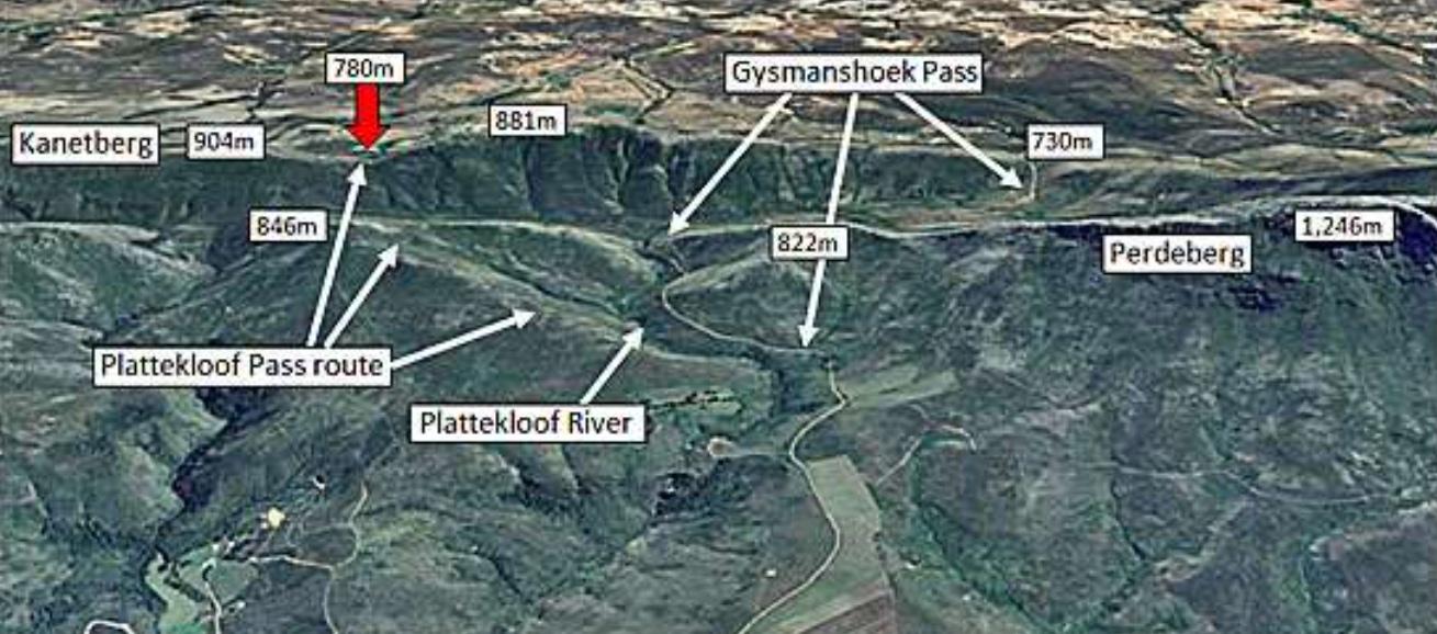
Figure 4: Google Earth image with heights of hills at Plattekloof and Gysmanshoek Passes. The red arrow indicates the neck of the Kanetberg where the Plattekloof Pass crossed over into Kannaland (upper portion of picture). The Perdeberg range to the south of Gysmanshoek cuts off any views of the sea from Gysmanshoek’s highest point, the 730m crossing at the eastern end of the valley. From the 846m high hill along the route of the Plattekloof Pass, the sea to the south is visible; from there the distant Klein Swartberg forming the northern side of Kannaland can also be seen, and from the 780m neck at Kanetberg the early traveller could see most of Kannaland laid out in front of them.
The only high ground from where they could see the Indian Ocean over the 734m high Amandelbos/Grootberg hills to the south of the Plattekloof valley is near the summit of the hill to the west of the Plattekloof River, the top of this hill is 846m above sea level. The track ran along the eastern slope of this hill just a few metres below the summit. The sea will also be visible from the high summit of the Perdeberg range to the east of the Plattekloof River, but the mountain is quite steep and there is no indication that an animal or wagon trail existed over this part of the mountain. It is difficult to believe that animals, and later humans, would have tried to cross the mountains east of the Plattekloof River while there was such an obvious easier route over the hills to the west of the river.
2.4 The View from Above
The most compelling evidence for the route of the old Plattekloof Pass is Google Earth imagery which clearly shows old tracks and pathways across the mountains. These old paths and trails are still visible for many of the old mountain passes across our southern mountains, including the Gantou Pass just north of the current Sir Lowry’s Pass and the Attaquaskloof Pass. Unfortunately the establishment of plantations in the mountains in the late 1800s into the 1900s has obliterated all signs of old tracks in some of the more interesting pre-1800 passes.
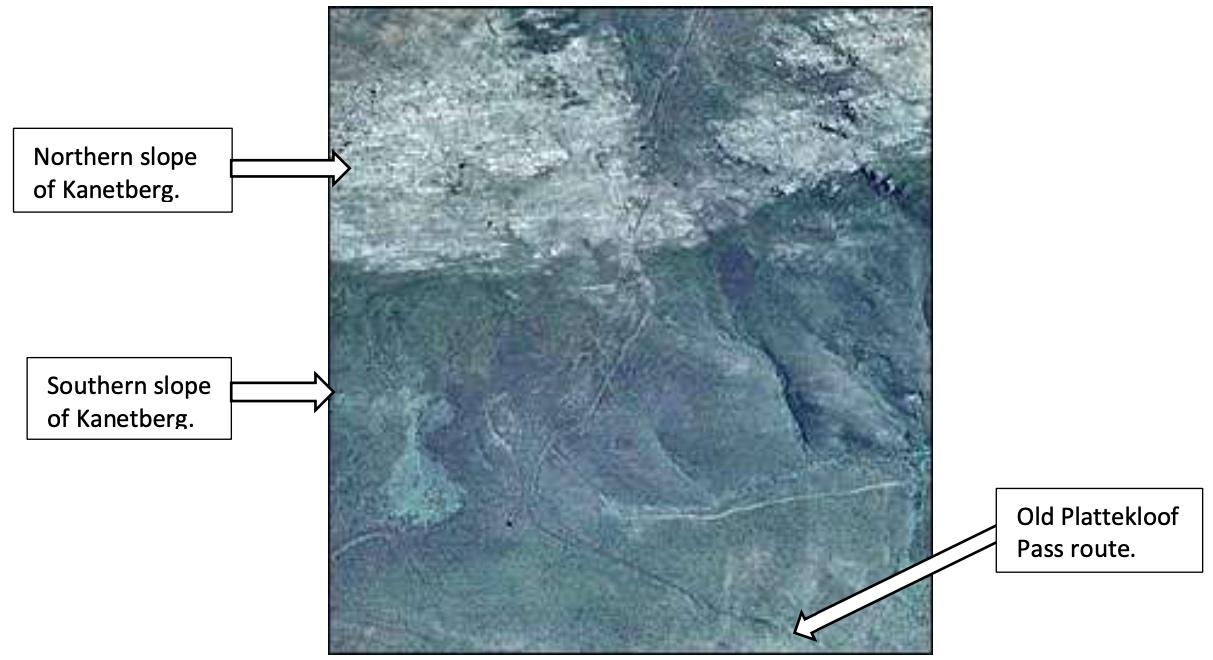
Figure 5: Google Earth close-up showing multiple animal and wagon trails approaching the summit at Kanetberg on the Plattekloof Pass route. The light coloured track on the southern slope leading off to the right of the picture, was created by farmers in the 1950s to enable them to transport wild flowers they were harvesting in the mountains. Below this track on the picture is a track leading off to the bottom right; this is the old route of Plattekloof Pass from the 846m high hill which lies to the south (see Fig 6).
The old Plattekloof Pass is easily visible on Google Earth images and clearly shows the trails up and over the hill to the west of the Plattekloof River and then northwards over the Kanetberg (Figures 5 & 6). There are no signs of old trails over the neck where the Gysmanshoek Pass crosses into Kannaland, but this does not necessarily mean that a trail did not exist there. The steep slopes of the Perdeberg show no sign of old trails, it can safely be assumed that there were no trails over the Perdeberg from Plattekloof farm to the Gysmanshoek area.
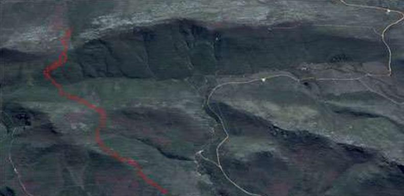
Figure 6: Google Earth pic showing portion of route of old pass south of Kanetberg. The track is marked by red dots, but is clearly visible on Google Earth if the picture is magnified. The road on the right of the picture is Gysmanshoek Pass along the eastern slope of the Plattekloof River gorge.
2.5. The tracks of ox-wagons
Dr Graham Bell-Cross was a fisheries scientist in Zimbabwe (he was the author of the 1976 book “Fishes of Rhodesia”, and the 1988 “Fishes of Zimbabwe” co-authored with John Minshull). He moved to East London Museum in the 1980s, and then to Mossel Bay a few years later to the Bartolomeu Dias Museum. In 1991 the museum held a special exhibit on the mountain passes of the Langeberg and Outeniqua Mountains and Bell-Cross was responsible for most of the fieldwork and research. During this time I had several conversations with him about the passes in the Riversdale area, and also assisted him with names of local people he could contact to get more information.
After publication of his report (co-authored by Jansie Venter), he mentioned to me that he had walked sections of the old Plattekloof Pass, and they clearly saw the tracks of ox-wagons. BartoIomeu Dias Museum kindly provided me with photographs of the old route that Bell-Cross and Jansie Venter walked, as well as a copy of a 1:50 000 topo-cadastral map on which he sketched the route they followed (Figures 7 & 8).
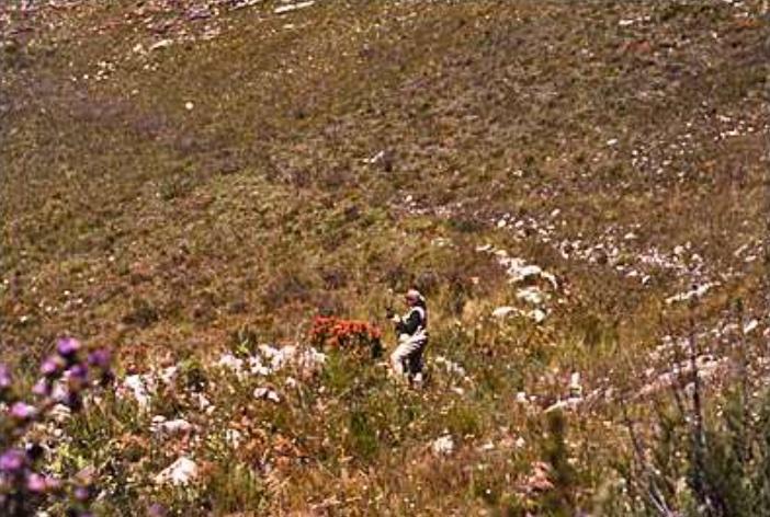
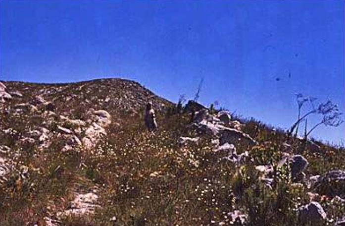
Figure 7: Photographs taken by Graham Bell-Cross of old Plattekloof Pass route (his co-author Jansie Venter appears in the pictures). These clearly show where rocks were rolled aside to form a “roadway” along a route probably thoroughly tramped out by elephants, large game and the stock of Khoekhoen pastoralists over the years. [With kind permissioin of Bartolomeu Dias Museum, Mossel Bay].
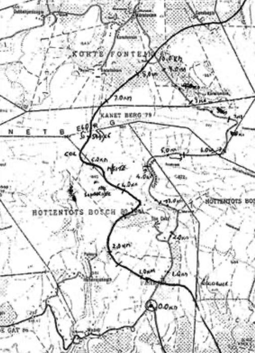
Figure 8: Copy of 1:50 000 map (3321CC Muiskraal) on which Bell-Cross and Venter sketched the route of the pass they followed from The Oaks to Kortefontein (on their map they marked the route in pencil, for clarity we have drawn over the route in black ink). The road on the right from near the bottom of the map to the centre top is the Gysmanshoek Pass. To the left of this the route of the Plattekloof Pass they walked (and pictured in Fig 7) is marked in, the numbers written in is the kilometres from where the Gysmanshoek road turns off the road from Riversdale through Plattekloof Farm and on to Heidelberg (see Fig 1). A handwritten note at the bottom of the map states that the wagon track to Plattekloof Farm crosses the Gysmanshoek road 0.7 to 1.0km from the turnoff (marked 0.0km). The route of this track is drawn in the lower right section of the map – it crosses the Duiwenhoks River at Plattekloof Farm at the drift where the present road crosses the river (off above portion of map). (With kind permissioin of Bartolomeu Dias Museum, Mossel Bay].
During March and April 2017 I was contacted by Dick Metcalf of Prince Alfred who was interested in old mountain passes. In an email he writes that a team led by Richard Macintyre walked the route of the old Plattekloof Pass on 24 September 2015 with the permission of the land-owner. The group started at the farm The Oaks, and followed the route over the mountain to the farm Kortefontein. Metcalf writes as follows:
The route was comparatively easy to follow as a fire had run through this area about two years previously. We found rocks marked by the wagon wheels, and sections where rocks had been moved aside along the trail. The route kept to the ridge, as expected, and was on bare rock a large proportion of the way. It passed the peak marked on map 3321CC as 846m, then down through the saddle and up over the Kanetberg to the farm Korte Fontein. This walk took about three hours.” (Metcalf, 2017).
It is interesting to note that Gordon and Paterson also described the length of the journey over the mountain as between 2 1⁄2 and 3 hours. The farmer at The Oaks also told the group about an old ruin at the foot of the hill and to the west of The Oaks farmhouse which he suspected was an old tollhouse for Plattekloof Pass (Metcalf, 2017).
2.6 Tolls tell a story
Apart from the old ruin near The Oaks which is reputed to be a tollhouse, there was a tollhouse at the southern entrance to Gysmanshoek Pass – the ruins of the old building are still there in a small copse of trees next to the road quite close to the mountain.
The VOC kept detailed records of tolls where they were collected at many of the passes over the mountains, e.g. travellers through Attaquaskloof in the 1700s are well documented. Research by the Drostdy Museum at Swellendam reveals records of treks over Plattekloof Pass between 1748 and 1789, but the numbers are fairly low compared to those using the Attaquaskloof Pass (reported by Pretorius, 2004). The problem for travellers to the eastern Cape was that, once having crossed Plattekloof Pass, they still had a very difficult journey eastwards through Kannaland. The Huisrivier / Rooiberg / Gamkaberg mountain range extending south from the Swartberg had deep gorges and could not easily be crossed by ox-wagon – the easiest route eastwards was in the valley between Gamkaberg and the Langeberg and Outeniqua mountains and onto the trails leading north and east from Attaquaskloof.
There is a reference to tolls at Plattekloof in 1843 in a request to the Colonial Secretary in London “...for establishing a Toll on the Plattekloof Pass.” (Metcalf, 2017), but this was most likely for setting up the toll station at Gysmanshoek Pass.
In the 1869 “General Directory and Guide Book to the Cape of Good Hope” the following entry appears under “Riversdale”:
The only toll in the district is at Plattekloof. The charges are as follows:
For a loaded wagon ...... 1s 6d
For an empty wagon ....... 1s 0d
For a cart with 2 or more horses ...... 1s 0d
For a saddle horse ....... 0s 3d
For 100 sheep or goats ...... 1s 0d
For every horse, cow, ox, or other head of horned cattle ...... 0s 1⁄2d.”
In the 1880 and 1882 General Directories, the entries refers to “at Plattekloof and Garcia’s Pass”. All entries referring to “at Plattekloof” and “Garcia’s Pass” are written in the singular – the entries are not “Plattekloof Pass and Garcia’s Pass” or “Plattekloof and Garcia’s Passes.” This is most likely an indication that “Plattekloof” refers to the farm (or locality) Plattekloof where tolls were collected, and not specifically to Plattekloof Pass (which was no longer in use by this time). My conclusion is that during the late 1800’s the “Plattekloof” tolls were collected at the entrance to Gysmanshoek Pass.
2.7 Finally: an interesting diagram
A diagram of the farm Hottentot’s Bosch dating from 1845 shows two roadways across the mountain from the Plattekloof Farm to Kannaland (both Plattekloof and Gysmanshoek Passes are mostly situated on the original Hottentot’s Bosch farm). The road to the east of the Plattekloof River gorge is the Gysmanshoek Pass before a small section was rerouted in 1860; the other road is over the hill west of the river and on to the neck over the Kanetberg, i.e. the route of the old Plattekloof Pass (Fig 9).
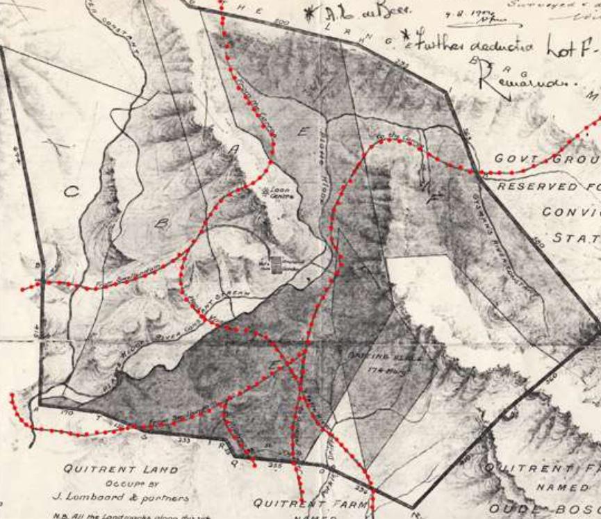
Figure 9: Diagram of Hottentot’s Bosch, original by Government Surveyor W M Hopley dated 1 February 1845 (only a portion of the original diagram is shown here). The diagram shows several tracks crossing the mountain; although there are no names attached to the tracks, only the places to which they lead, it is obvious that the track on the left is of the original Plattekloof Pass and the one on the right is the Gysmanshoek Pass. The tracks leading northwards are described as “From the Carroo” on the left (the Plattekloof Pass) and “to the Carroo” on the right (the Gysmanshoek Pass). South of the mountain range the tracks from the two mountains divide and join up, the junctions are on the flat ground east of the Plattekloof River (the plateau where the road to Gysmanshoek branches off from the Plattekloof road between Riversdale and Heidelberg. From the left (west) to the right (south-east) the descriptions written in alongside the tracks are as follows: the first two on the branching out to the left of the diagram are both marked “From Swellendam”; from the lower one the track southwards is marked “to Kragga”; further along the road is marked “to Spiegels Rivier”; with the one furthest right going to “Vette Rivier”.
On the diagram the descriptions of these roads are quite interesting; the northern parts for the Plattekloof Pass and the Gysmanshoek Pass are respectively marked as “From the Carroo” and “to the Carroo”. South of the mountains both branch into several different roads. The Plattekloof Pass has a western branch “From Swellendam”, an eastern branch crosses the Plattekloof River and joins up with the Gysmanshoek road. The Gysmanshoek Pass also has a branch “From Swellendam” to the west, and then several branches marked “Kragga”, “To Spiegels Rivier” and “To Vette Rivier”. The road to Swellendam probably crossed the ‘Ertjiesrivier se Berg’ and then went on to the Grootvaderbos area; those to Kragga and Spiegelsrivier crossed the Grootberg and Amandelbosberg, the former probably to the Holbak region; the road east to Vetterivier would have gone over the farm Oudebosch and probably on down the valley crossing over the hills to the Naroo valley (now known as Klein Vetterivier).
3. Conclusion
The facts described in this report leave no doubt that the original Plattekloof Pass was a separate route west of the Plattekloof River and not along the route of the current Gysmanshoek Pass. The later confusion was most probably due to the fact that Plattekloof Farm was a well-known farm in the district, and that the eastern catchment area of the Duiwenhoks River between the Langeberge and the Amandelbosberg/Grootberg to the south was generally known as Plattekloof.
It is interesting that Vernon Forbes’ remarks about the “parallel track” published in his 1986 book (Forbes, 1986) were apparently ignored by later writers, and it is unfortunate that Bell-Cross and Venter’s 1991 report was not published widely. Both Carina Erasmus and Frans van Wyk published their works before 1991 (Van Wyk died in 1988 before publication of his book), but neither researched the origins of the pass in any depth, most probably because they concentrated on the history of the town, Riversdale.
Subsequent publications about Riversdale or about the mountain passes in the district, merely repeat the assumptions made in the histories written by Erasmus (1987) and Van Wyk (1988), namely that the current Gysmanshoek Pass was originally the Plattekloof Pass.
In his 2004 article in the VASSA Journal, André Pretorius relates that the old Plattekloof Pass was little more than a track over the hill behind the farm The Oaks. He states that taking the poor condition of the Plattekloof Pass into account, “... it was not surprising that a second, less rigorous, passage over the daunting Langeberge was created close by and almost parallel to the original pass.” (Pretorius, 2004).
From the evidence presented above, there can be no doubt that Plattekloof and Gysmanshoek were and are two distinct and separate mountain passes over the Langeberg. Both are interesting passes, and form a fascinating part of the history of the Hessequa district.
About the author: Niel van Wyk, a retired environmental scientist living in Stilbaai, grew up in Riversdale and has a keen interest in the history of the district. The farm Plattekloof at the foot of Plattekloof Pass and Gysmanshoek Pass was in his family for more than 130 years, thus his specific interest in these two mountain passes.
Bibliography:
- Bell-Cross, Graham. 1991. Personal communication.
- Bell-Cross, Graham & Jansie Venter. 1991. The Passes of the Langeberg and Outeniqua Mountains. Bartolomeu Dias Museum, Mossel Bay.
- Burman, José. 1981. The Little Karoo. Human & Rousseau, Cape Town.
- Burman, José. 1988. Towards the Far Horizon. Human & Rousseau, Cape Town.
- De Jongh, Michael. 2016. A Forgotten First People: The Southern Cape Hessequa. The Watermark Press, Durban.
- Erasmus, C.J. 1987. Die Geskiedenis van Riversdal 1838-1900. Referaat vir MA (Geskiedenis) graad by UNISA.
- Forbes, Vernon S. 1965. Pioneer travellers of South Africa. A.A.Balkema, Cape Town.
- Forbes, Vernon S. & John Rourke (Editors). 1980. Paterson’s Cape Travels, 1777 to 1779. Brenthurst Press, Johannesburg.
- Forbes, Vernon S (Ed). 1986. Carl Peter Thunberg. Travels at the Cape of Good Hope 1772-1775. Second Series No 17, Van Riebeeck Society, Cape Town.
- The General Directory and Guide Book to the Cape of Good Hope and its Dependencies. 1869. Saul Solomon & Co, Cape Town.
- The General Directory and Guide Book to the Cape of Good Hope and its Dependencies, as well as the Transvaal, Griqualand West, Natal and the Free State. 1880. Being Leap Year. With Calendar and Four Maps. Saul Solomon & Co, Cape Town.
- The General Directory and Guide Book to the Cape of Good Hope and its Dependencies, as well as Natal, Free State, and the Transvaal. 1882. With Calendar and Gardening Directions. Saul Solomon & Co, Cape Town.
- Metcalf, Dick. 2017. Personal communication re Plattekloof and Gysmanshoek Passes.
- Mountain Passes of South Africa. 2016. www.mountainpassesofsouthafrica.co.za.
- Oakes, Dougie (Ed). 1988. Illustrated History of South Africa – The Real Story. The Reader’s Digest Association of South Africa (Pty) Ltd, Cape Town.
- Pretorius, André. 2004. Plattekloof – An abandoned pass, an eighteenth century farm with historic homestead, and a painting of a mysterious lady. VASSA Journal No 11, June 2004.
- Raper, Peter E. & Maurice Boucher (Editors). 1988. Robert Jacob Gordon: Cape Travels 1777 to 1786 (Vol 1). Brenthurst Press, Johannesburg.
- Van Wyk, Frans. 1988. Riversdal 1838-1988. Nasionale Boekdrukkery, Kaapstad.
- Van Wyk, Niel. 2018. Aan de Plattekloof – Plase en Passe. Stilbaai.
- Whitehead, Marion. 2018. South Africa’s Favourite Passes and Poorts. MapStudio, Cape Town.