Maps are designed for a variety of purposes; they may reflect our history, visual perspective of earth, seas and skies; scientific and technological developments and even our social history and culture. They are, therefore, important heritage artefacts.
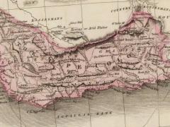
In 1755 a small map by the French astronomer, Nicolas-Louis de Lacaille (1713-1762), dramatically changed the representation of the shape of the coast of the Cape (of Good Hope) on printed maps.
Background
Lacaille is best known for his pioneering charting of the southern skies in 1752 and 1753, from his observatory in Strand Street, Cape Town. After completing this project, he had to wait some time before a French ship could take him to Mauritius, his next destination. So, he set about the first quantitative experiment in southern Africa. He tested an hypothesis on the symmetry of the shape of Earth; this required a trigonometric method that involved accurate astronomical determination of longitude and latitude, careful measurement of the length of a baseline using calibrated rods and calculation so he could determine the terrestrial distance of one degree of latitude at the Cape. His measurements were accurate, and his trigonometry correct. The results were a surprise, however: the distance was longer than expected. So, he remeasured the length of his baseline and checked his calculations. He could find no error in his measurements or calculations, so he came to the ineluctable conclusion that the southern hemisphere bulged relative to the northern hemisphere: a pear-shaped Earth!
Almost a century later, Thomas Maclear took...