Disclaimer: Any views expressed by individuals and organisations are their own and do not in any way represent the views of The Heritage Portal. If you find any mistakes or historical inaccuracies, please contact the editor.
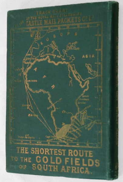
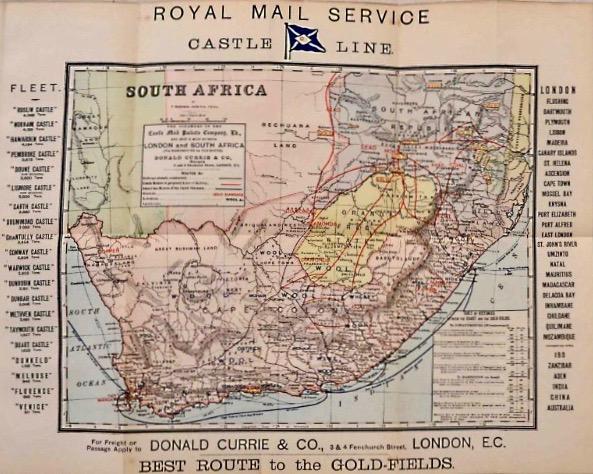
The map above is of considerable interest as it shows the principal route of travel to South Africa and from the principal ports inland. By 1889 the railway had reached Kimberley from the coastal ports of Cape Town and Port Elizabeth and East London; and in Natal the railway went as far as Ladysmith. The Lorenco Marques railway connection went inland as far as Komatipoort. From the terminal points the traveller proceeded by coach. This was the heyday of coach travel through the Orange Free State and the South African Republic. The economy of South Africa is indicated in what was produced where - wool, ostriches, mohair and wheat were the principal agricultural products. Diamonds drew hopeful immigrants to Kimberley and in the ZAR there was the lure of minerals - gold, lead, coal and iron were the magnets. Gold is labelled in a vague way 14 times. This signals that gold fever had really taken hold. To the left of the map are listed the fleet of the Castle Line and the tonnage of each steam ship – it was a fleet of 20. The right hand border lists the possible destinations from London to Mozambique and connection with other ships moving on to India, China and Australia. A box within the borders of the map shows distances from Cape Town to Johannesburg and Barberton, in miles and hours. In 1889 the journey from Cape Town to the Witwatersrand via train and then by mail or passenger coach took a hopeful 85 hours, approximately 4 days.
Donald Currie and company’s offices were at 3 and 4 Fenchurch Street, London. This was where you purchased your passage ticket.
Castle Line Ticket
Last weekend I visited James Findlay’s new bookshop located in the basement of the Rand Club. It is always an occasion to browse maps and books. This is now an emporium of delight – there are shelves of books and deep cradles for the maps and posters. One’s eye falls on at least six desirable items. I will always find a rare book treasure to carry home in triumph. I had several good finds, but the most unusual was a small book, dated 1889: entitled South Africa and How to Reach it by the Castle Line. It is the second edition and it seems that at least 20 000 copies were printed. It is a guide book and now regarded as rare and of course highly collectable. At one time it must have been a very common little guide book and the obvious vade mecum if you were on your way to the Cape and then inland by train and coach to the gold fields of the Transvaal.
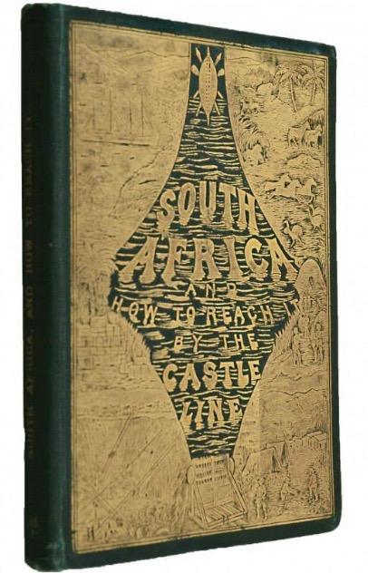
Front Pictorial cover of South Africa and How to Reach it with gilt embossed vignette illustrations.
This was the Lonely Planet guide of its day. It is likely to have been lost on the journey, dropped in a fast flowing river when making a crossing. But some copies must have become souvenirs or belonged to people who did not make the journey. I fell instantly in love with this little book and returned home to begin an online search for any information available.
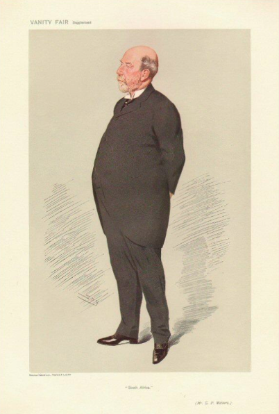
Vanity Fair Cartoon of Edward P Mathers.
It is a book that will bring back fond memories to anyone who travelled to or from England via one of the Union Castle liners pre 1977 (when the service ceased). People will immediately feel a personal connection and because you have lived a voyage or two you can identify with the 1889 traveller. This guide will speak to you. In the fifties and sixties many young people went off to Europe to experience widening horizons or to study abroad. I embarked on a great adventure in 1968 when I travelled by the Windsor Castle to Southampton from Durban and returned to South Africa some 3 years later on the same Windsor Castle to Cape Town and then a Blue Train journey to Johannesburg to take up my first permanent job. So the Mathers book immediately claimed ownership.
If you were intending to head for South Africa in 1889 departing from London, this was the guide of the year. I found that a copy had been sold on the Antiquarian book auction site about a year ago. It was described as:
An unusually fine copy of this attractive 204pp. booklet detailing the sea voyage to the Cape and with much information (statistical and general) about the South Africa of 1889 including the Gold Fields. With several attractive black and white illustrations and a coloured frontispiece of the Norham Castle and a large coloured folding map of South Africa. The second edition (Twentieth Thousand). Bound in green limp cloth with wonderful detailed illustrated decoration in gilt including a map of Africa on the rear cover which states "The Shortest Route to the Gold Fields of South Africa".
It is the gilt cover filled with detailed vignettes of those imagined exciting romantic scenes of African life - palm trees, the big hole of Kimberley, wild game, a stamp battery, Johannesburg as a mining camp, indigenous rural tribal life and crossing the Atlantic to reach this Eldorado. The rear gilt cover is even more appealing – what is called a track chart of the route taken by the Royal Mail Steamships of the Castle Mail Packets Company Limited and reminding the reader that this was “ the shortest route to the Gold Fields of South Africa. The gilt image against a green background is a map of Africa in relation to Europe. It immediately reminded me of those maps of Africa at the back of the airline promotional magazines, now we travel in a direct line over the continent and it is an overnight journey of 9 or 10 hours. In 1889 it was a sea voyage of up to three weeks, with plenty of time to read Mathers' guidebook to South Africa as you reclined on your deck chair.
The back cover of the book with gilt map of Africa showing the optimistic shortest route to the Gold Fields of South Africa via a sea voyage, train and then coach.
A delight of this book are the illustrations - 10 pages of vignette sketches of South African ports - Cape Town, Port Elizabeth, East London and interior scenes of Natal country, Kimberley, Barberton. A particularly charming page is the one showing the Gold Fields Coach, De Kaap Gold Fields and the Komatie River. There is a final sketch of the RMS Hawden Castle. The artist is indicated only by the initials J F W.
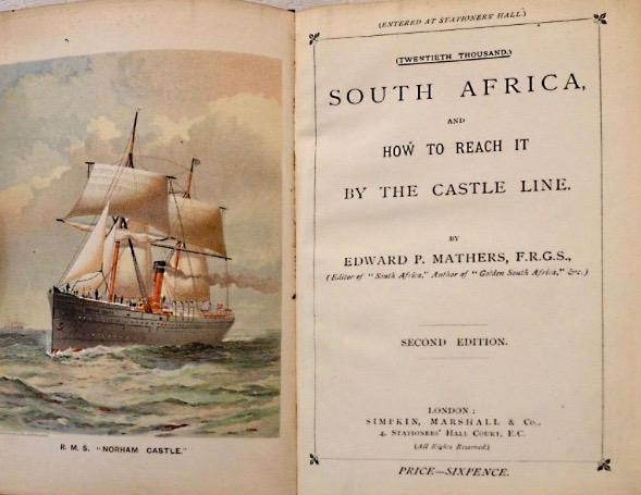
The frontis page shows a chromolithograph illustration of the Norham Castle. There was an interesting history to this ship. The Norham Castle was a mail cum passenger ship steamer. Its tonnage was 4 241 tons and it was specifically designed in 1883 to meet the requirements of the new mail contract of 1883 and to reach Cape Town within 21 days. During her lifespan there were two unfortunate breakdowns with a shattered propeller and rudder in one and broken cylinder head in the other.
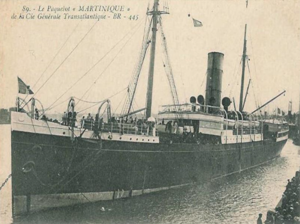
Despite these misadventures, the Norham Castle outlasted both her sister ships the Hawarden and the Roslin. In 1903 the Norham Castle was sold to the French firm of CGT and renamed the Martinique, and in 1932 was sold to Italian ship-breaking yards.
Title page of South Africa and How to Reach it - with facing chromolithograph of the Royal Mail Ship (RMS) Norham Castle.
The Norham, post 1900 when renamed the Martinique (via Clyde Ships)
This book is dense with essential information. It starts with some suggestions as to the contemporary literature the traveller ought to read. In 1889 you would be up to date with Anthony Trollope (a brace of volumes of South African travel classics still in print today), John Noble (South Africa Past and Present), the historian George Theal (History of South Africa among other titles) in addition to numerous handbooks and almanacs, memoirs and travel books on 19th century travel.
Mathers' style was to describe the outward voyage to the Cape by quoting liberally from experienced travellers who had written up their impressions. The chapter on the voyage to South Africa is fascinating because he covers all the places the Castle ships called at en route to the Cape: Lisbon, Madeira, the Canary islands followed by a mention of “other landmarks” of the Atlantic - St Helena and Ascension before arriving in Cape Town. The book gives a comprehensive coverage of what the prospective immigrant or traveller could expect to encounter on adventures to Cape Town, Port Elizabeth and East London, Natal, Basutoland, Bechuanaland, and then to the Orange Free State the South African Republic and the ultimate destination described as “the South African Gold Fields”. There is also a chapter on the East Coast Ports (but this is no more than a brief mention of the Mozambique ports, Zanzibar, Mauritius and Madagascar). The latter part of the book is replete with useful information about the Castle Line and its history, the naval architecture of three of the largest vessels at that date: the Norham, the Hawarden and the Roslin Castle ships. These were all steamers but were also fitted with sails. The typical menus of meals in first second and third class sections of the ship is helpfully detailed. Although the rates of passage money is discussed, no precise figures are given, though it is fascinating to learn that a cow was taken on board to supply fresh milk and these steamers were state of the art in their day with electric lighting and refrigeration chambers. The final section covers all the useful data on weights, measures, distances.
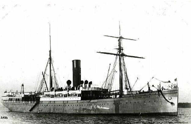
SS Hawarden Castle (from British Ships to South Africa in the 1800s published on Geni.com). The S.S. Hawarden Castle was built and launched in 1883; it was an iron screw passenger line. It was steam powered but also carried sails. It combined as a passenger, cargo and mail ship. Tonnage: Gross - 4341 tons Net - 2772; Length: 380.6 feet; Breadth: 48.2 feet. Owner History: Castle Mail Packet Company. The name of the ship was given in honour of Donald Currie’s friend the English Prime minister WE Gladstone, as his home was Hawarden Castle in Wales.
It is interesting to read more about the later history of the Hawarden. It was subsequently sold to a Liverpool Company, SS Booth and renamed the Cyril 2. In 1905 the ship was involved in a collison with another ship on the Amazon River and sank with its cargo of rubber. The cargo was salvaged but the Cyril was a complete loss.
Food on board ship appears to have been plentiful and the more so for the first class passengers but even the third class passengers would not have starved with soups, roast goose and sauce, roast beef, potatoes and other vegetables, plum puddings, mince pies, oranges apples and nuts. The Hawarden Castle, a vessel of some 4 300 tons accommodated 190 first class and 160 second class passengers. The ship was equipped with 10 boats of which 8 were lifeboats so interesting that safety at sea was of concern.
I was particularly interested in sections on the South African Republic and the Goldfields. The table on the Districts, Chief Towns and other Villages lists Heidelberg as the district with Heidelberg town as the chief town and under Other Villages, Johannesburg is listed (though it is stated to be “an important town” in parentheses). There is a condensed description of gold exploration history in the South African Repulic and further north into what later became Rhodesia. One catches the intensity of the gold fever in the uptick in prospecting activity from the 1850s with prospectors and geologists such as Dunn and Carl Mauch (in Matebele country). After 1869 Lydenberg, McMc and then came Pilgrims Rest (post 1873) and later Barberton and the Komati Goldfields. Finally there is a description of the Witwatersrand, described by Mathers as the most promising of all the gold-fields in the Transvaal. Johannesburg in 1889 was still a mining camp but it was on its way to permanence and solidity. It was just three years old. The first auction of building stands was held on 8th December, following the declaration by the Government of a township, and an amount of £13 000 was realized. In January of 1887 a total of £16 921 was realized and by April 1887 a further £20 000. The description of Johannesburg is worth quoting:
Buildings of a character infinitely more substantial than those that are generally to be met with in a mining township were run up with lighting rapidity, and it is estimated that about two million have been already expended upon wood, iron, stone, bricks and labour wholly independent of the cost of the stands. There are a large number of places of worship, a handsome pile of Government offices occupying one end of the huge market square, theatres and music halls, excellent hotels and clubs, two stock exchanges, half a dozen newspaper offices and all the other evidence of advanced civilization.
It is interesting that Mathers draws a distinction between Johannesburg township and other townships - so he lists Ferreira (800 stands), Booysens (300 stands), Marshalls (600 stands), Doornfontein (300 stands) and Natal Camp (200 stands) as separate townships.
Edward Mathers, the author of this guide is someone worth knowing more about. He was born in Edinburgh and was evidently a Scot. He became a journalist in England and emigrated to South Africa in 1878. He worked for various newspapers and became the founder-editor of the Natal Advertiser (a paper that survived until 1937). Matthers himself travelled throughout the Transvaal gold fields in the 1880s and was regarded as the first journalist to express confidence in the future prospects of gold mining. Matthers was a keen British imperialist and the colonial vision. He returned to England in 1888 and founded the weekly newspaper South Africa (lasted from 1889 to 1961) and early issues are very collectable. Mathers died in London in 1924. During his life time he published a number of guidebooks on South Africa and apart from this specific book his book Golden South Africa (or The gold fields revisited) gave further glimpses of the gold fields of South Africa (this is a highly collectable item). In 1895 he published Zambesia, England's El Dorado in Africa, being a description of Matabeleland and Mashonaland, and the less known adjacent territories, and an account of the gold fields of British South Africa. Some of these titles can be accessed in digitized format online.
I wondered if the Mathers book South Africa and How to Reach it was sponsored by Donald Currie and the Castle Line. The original price was 6d but the book was clearly a high quality advertorial for Donald Currie and Company.
Vanity Fair cartoon of Sir Donald Currie - “Knight of the Cruise”, 1884
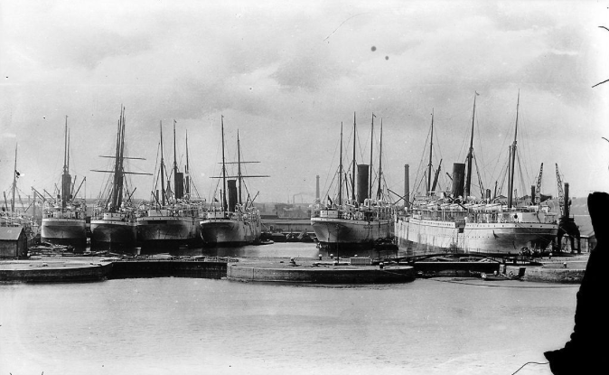
Union Castle Line ships docked at the East India Docks London in 1902 (via Wikipedia)
Kathy Munro is an Honorary Associate Professor in the School of Architecture and Planning at the University of the Witwatersrand. She enjoyed a long career as an academic and in management at Wits University. She trained as an economic historian. She is an enthusiastic book person and has built her own somewhat eclectic book collection over 40 years. Her interests cover Africana, Johannesburg history, history, art history, travel, business and banking histories. She researches and writes on historical architecture and heritage matters. She is a member of the Board of the Johannesburg Heritage Foundation and is a docent at the Wits Arts Museum. She is currently working on a couple of projects on Johannesburg architects and is researching South African architects, war cemeteries and memorials. Kathy is a member of the online book community the Library thing and recommends this cataloging website and worldwide network as a book lover's haven.
Comments will load below. If for any reason none appear click here for some troubleshooting tips. If you would like to post a comment and need instructions click here.

