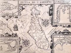
On first inspection, this small map (20 x 14 cm) is unimpressive and would seem to be of little heritage interest to South Africa. But why the four small insets in the corners? Once I had confirmed the source of the map, I started to delve into the stories it revealed.
The map
The title of the map is in Latin (Insula de S Lauenty, i.e., the Island of St. Lawrence) as is the page headline Insula Madagascar alias S. Laurentii Dicta, & huius conditio (The island of Madagascar, otherwise called St. Lawrence, and its condition). Despite the Latin title, many of the place names are in Portuguese.
Not unexpectedly, the small chart includes a ship sailing through the Mozambique Channel, two compass roses from which rhumb lines (compass bearings) emerge.
There are tiny inset maps in each corner of the map boundary: Insula de S. Maria (Island of Saint Mary); Baija Antongil (Antongil Bay); Porto de S. Augostine (The port of Saint Augustine) and Caemetrium Battavorum (Dutch Cemetery).
The text below the map is also in Latin and provides the key to the letters on the insets.
‘Madagascar is drawn here, with its sands and rocky cliffs: “A” is the place where we first anchored, “B” Is the island where many of the sailors were buried in the Dutch Cemetery, “C” a fresh-water lake, “D” a stream of fresh-water, “E” the Dutch trench, “F” the corner of the port of St August, “G” A small island to...


