Driving through the Karoo town of Graaff-Reinet as a tourist, the dam wall just north of town does not seem worthy of attention, yet a number of historical photographs recently collated confirms the significance of this engineering project which took just short of five years to complete (between 1920 and 1925).
Through the efforts of a civil engineer, Johannes Haarhoff, who happens to have retired in Graaff-Reinet, three photographic collections were combined and diligently analysed and interpreted, resulting in the splendid end result – a book published on behalf of the Graaff-Reinet Museum – already colloquially referred to as “the dam book”. This was an assignment right up his alley considering his academic interest in engineering projects relating to water.
The three photographic collections he relied on in providing the combined historical narrative were:
- Graaff-Reinet Museum Photographic Digital Collection;
- Hardijzer Photographic Research Collection;
- Johan Loock – photo album in private collection.
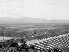
The end product is a publication of 56 pages containing 83 historical images with accompanying text presenting a detailed historical visual narrative of the dam wall under construction.
The intention of this article is not only to create awareness of the above publication but also to provide a condensed historical narrative, with some images from the same publication included. See details of how to go about ordering this publication at the end of this article.
The dam is located at the convergence of four rivers (some intermittent), namely the Sundays River (or Nukakamma), Gatsrivier, Pienaarsrivier and Broederstroom. Located in...